Return to home page
Go to TGO CHALLENGE 2007 page - includes report

Go to TGO CHALLENGE 2008 page - includes links to blog postings

Go to TGO CHALLENGE 2009 page - includes links to blog postings

Go to TGO CHALLENGE 2010 blog postings

Go to TGO CHALLENGE 2011 page - includes a link to blog postings

TGO CHALLENGE 2012

Sue is back this year, for her third Challenge, whilst Martin will be crossing Scotland for the sixth time. As Sue's neck still prevents her from carrying anything more than a bum bag.... she's not going to carry anything more than a bum bag, That should make for an interesting crossing, which at nearly 400km (250 miles) is rather longer than our previous efforts.

Martin will be blogging as he lumbers along. The entries will be here - you'll need to scroll down to the earliest posting and work backwards up the page to view the entries in chronological order. Photos will be added in due course (a job that still needs to be done in relation to 2010 and 2011). I'll be trying to tidy all this up later in 2012!

Planned route details are shown below, and you may wish to refer back to these if following the blog, as this year the daily 'plan' map will not appear on the blog. Whilst a number of others in the UK Outdoors Blogger fraternity are taking part, not all of them enjoy the rigours of 'mobile posting' after a hard day's walk. Some links to such sites will be added later, but we know that Gayle and Mick will be recording their passage in Gayle's usual entertaining style, and Alan Sloman should be recording his adventures with an eclectic mix of companions.

Martin's kit summary is shown below. Sue isn't carrying enough to make a summary worthwhile.

Planned Route and Estimated Statistics
(M) = Munro
(C) = Corbett
(G) = Graham

(Ma = Marilyn)
(O = Other Hill)

Map
Day 1 Day 2 Day 3 Day 4 Day 5 Day 6 Day 7 Day 8 Day 9 Day 10 Day 11 Day 12 Day 13 Day 14 Summary statistics
Here's an overview of our entire route:
Martin and Poor Michael's planned TGO Challenge route - 2011
   

Day 1 - Friday 11 May
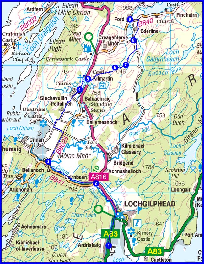
1 ARDRISHAIG (Grey Gull Inn)
3 Islandadd Bridge
5 Kilmartin
6 Beinn Bhan (Ma)
9 Ford

Plan
28 km
600 metres ascent
8.5 hours

(1 Marilyn)


Day 1 Map


Day 2 - Saturday 12 May
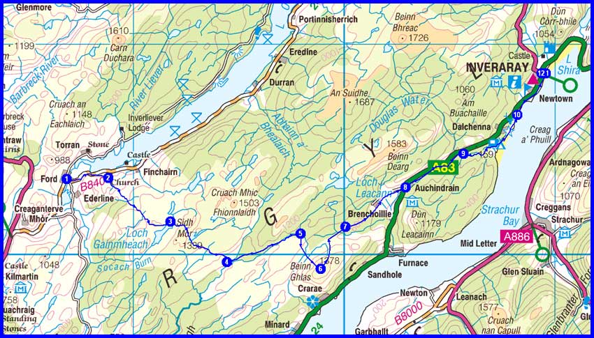
1 Ford
2 Church

3 By Loch Gainmheach
4 Carron
5 Turn for Beinn Ghlas
6 Beinn Ghlas (Ma)
7 Regain forest track

8 Auchindrain
12
Inverary

Plan
33 km
1000 metres ascent
11.0 hours
(1 Marilyn)

Day 2 Map


Day 3 - Sunday 13 May
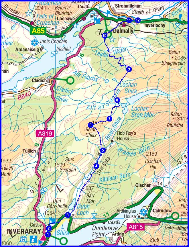
1 Inverary
3 Leave main road
4 Elrigbeag

5 Turn to ascend Beinn Ghlas

6 Beinn Ghlas (Ma)
7
Creag an Fhithich (O)
8 Join track near Lochan Shira

9 Join track near Bealach nan Cabrach
10 Track junction by monument
12 Dalmally

Plan
29 km
1100 metres ascent
10.5 hours

(1 Marilyn)
(1 Other)

Day 3 Map


Day 4 - Monday 14 May
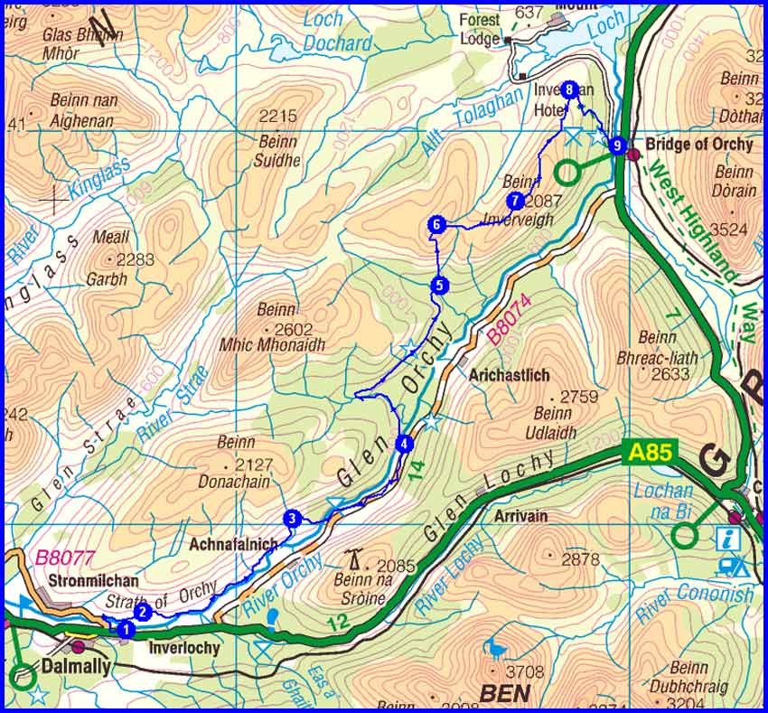
1 Dalmally
2
By Craig Lodge
4
Eas Urchaidh
5
Leave path to ascend Meall Tairbh
6 Meall Tairbh (G)
7 Ben Inverveigh (O)
8
Mam Carraigh
9 Bridge of Orchy

Plan
28 km
1100 metres ascent
10.0 hours
(1 Graham)

(1 Other)

Day 4 Map


Day 5 - Tuesday 15 May
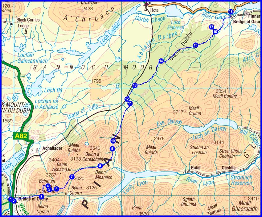
1 Bridge of Orchy
3 Col at 743 metres
4 Beinn an Dothaidh (M)
5
Point 993 metres
6 Head of Coire Achaladair
7 Head of Gleann Cailliche
8 Tigh nam Bodach

10
Col at Gleann Meran
12 Forest edge near railway
13 Join forest road
14 Track junction
15 Ruin near Lochan Dubh Grundd nan Darachan
17 Meall Chomraidh (Ma)
18 Bridge of Gaur

Plan
34 km
1400 metres ascent
12.5 hours
(1 Munro)
(1 Marilyn)

Day 5 Map


Day 6 - Wednesday 16 May
1 Bridge of Gaur
3 A E Robertson's Church
4 Leave path to ascend Leagag
5 Leagag (Ma)
6
Path junction
7 Bridge over Dall Burn
8 Join track by Allt na Bogair
9 Minor road east of Carie
11 Kinloch Rannoch

Plan
25 km
700 metres ascent
8.5 hours

(1 Marilyn)

Day 6 Map


Day 7 - Thursday 17 May
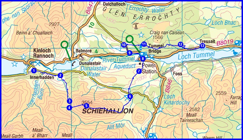
1 Kinloch Rannoch
2 Track junction
4 Leave track at Blar na Feadaig Bothy
5 Schiehallion (M)
6
Tourist Car Park
7 Creag Kynachan (O)
8 Join B846 road
9 Road junction

10 Track junction
11 Track junction
12 Track junction
13 Loch Tummel

Plan
28 km
1350 metres ascent
11.0 hours

(1 Munro)
(1 Other)

Day 7 Map


Day 8 - Friday 18 May
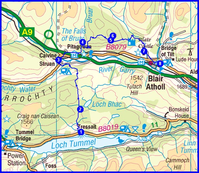
1 Loch Tummel
2 By Loch Bhac
3 Struan
4 The Falls of Bruar
6 Fair Bhuidhe (O)

7 Blair Castle
8 Blair Atholl

Plan
20 km
600 metres ascent
7.0 hours

(1 Other)

Day 8 Map


Day 9 - Saturday 19 May
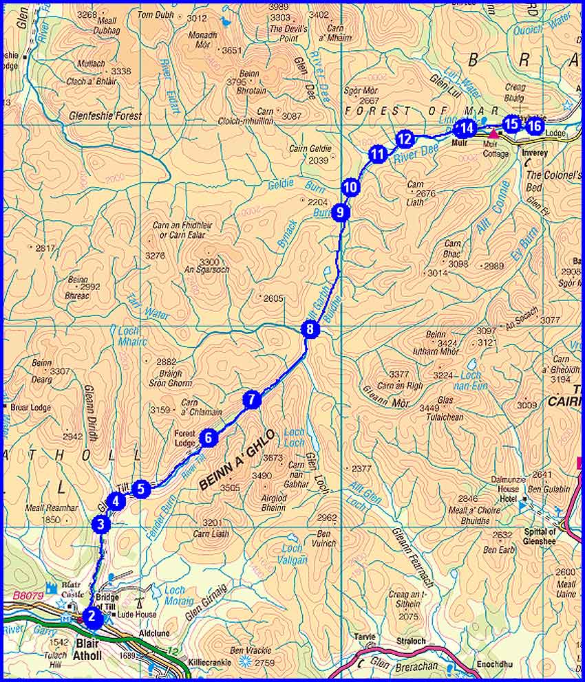
1/2 Blair Atholl
3 Gilberts Bridge
5 Bridge by Marble Lodge
6 Path junction by Forest Lodge
8 Falls of Tarf
9
Bynack Lodge
10
Geldie Burn
11
White Bridge
13/14 Linn of Dee
15 Mar Lodge

Plan
39 km
950 metres ascent
12.5 hours


Day 9 Map


Day 10 - Sunday 20 May
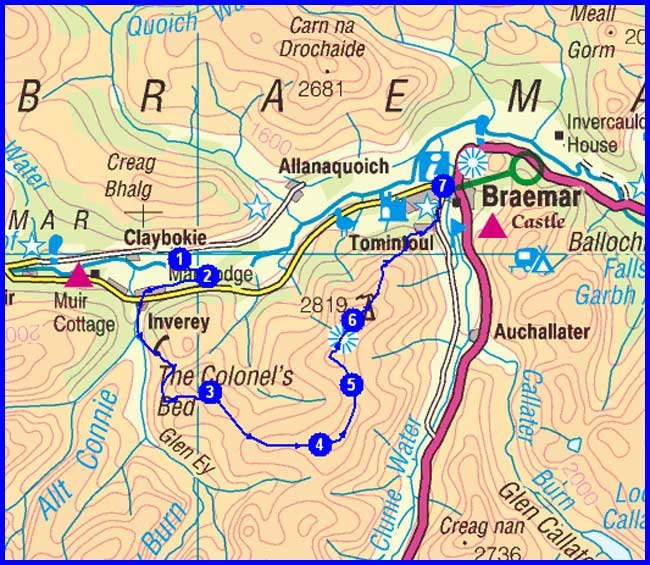
1 Mar Lodge
3 Carn Mor (O)
4 Carn na Drochaide (O)
6 Morrone (C)

7 Braemar

Plan
16 km
700 metres ascent
6.0 hours

(1 Corbett)
(2 Other)

Day 10 Map


Day 11 - Monday 21 May
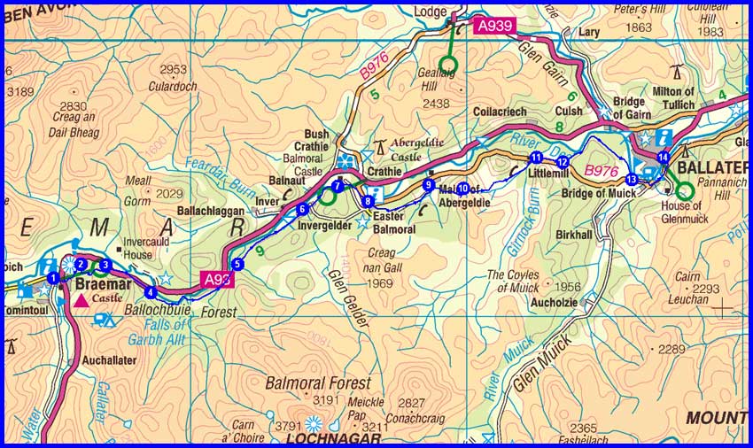
1 Braemar
2 Creag Choinnich (O)
3 A93 road

4 Invercauld Bridge
5 Connachat Cottage
6 Invergelder
7 By Balmoral Castle
8 Easter Balmoral
9 Path junction

10 Creag nam Ban (O)
11
Littlemill
12 Path junction
13 Path junction
14 Ballater

Plan
30 km
750 metres ascent
10.0 hours
(2 Other)

Day 11 Map


Day 12 - Tuesday 22 May
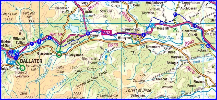
1 Ballater
2 Craigendarroch (Ma)
3 Join cycle track to Dinnet
4/5/6 Church and monument
7 By Cambus o' May
8 Dinnet
9 Aboyne
10 Disused railway line
11 Road junction - Drumduan
12 Kincardine O'Neill

13 Potarch

Plan
35 km
550 metres ascent
10.0 hours
(1 Marilyn)

Day 12 Map


Day 13 - Wednesday 23 May
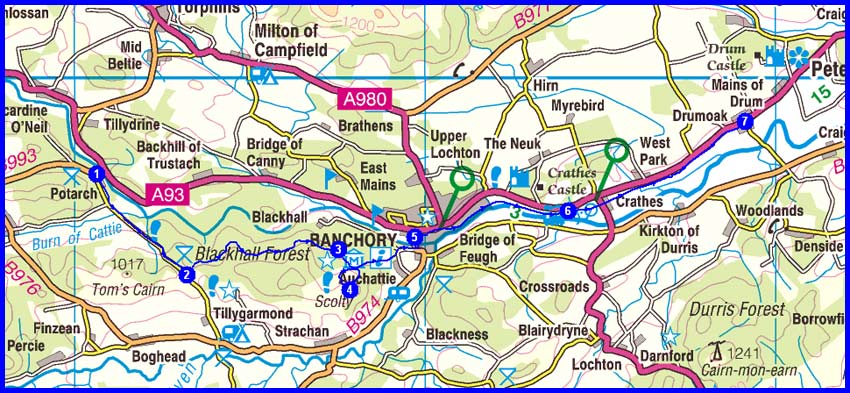
1 Potarch
2 Mountain Bike Trail junction
3 Track junction
4 Scolty (O)
5 Banchory
6 Milton
7 Drumoak

Plan
25 km
500 metres ascent
8.0 hours

(1 Other)

Day 13 Map


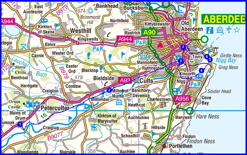
Day 14 - Thursday 24 May
1 Drumoak
2 Milton of Murtle
3 Duthie Park
4 Baron's Cairn (O)
5 Nigg Bay > finish at beach at NJ 965 046
Then return to Montrose via
5/6 St Fittick's Church
7 Aberdeen Station > train to Montrose

Plan
26 km
300 metres ascent
7.5 hours

(1 Other)


Day 14 Map


2012 Plan
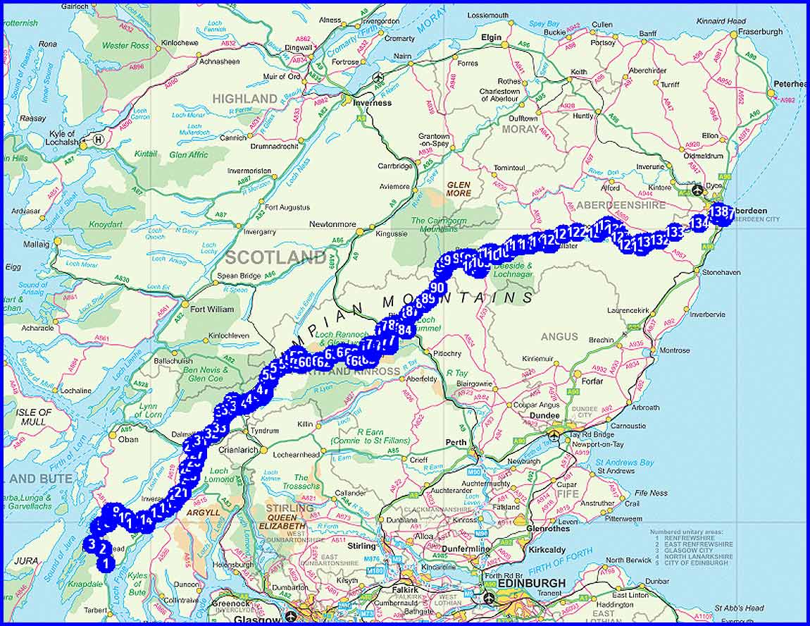
Total Distance 396 km (248 miles)
Total Ascent 11600 metres
Time
133 hours including stops

2 Munros
1 Corbett
1 Graham
6 Marilyns not included above
10 'Other' hills

NB Timings are based on 4.0 kph, plus an hour for each 500 metres of ascent and another hour for each 1000 metres of descent. This is realistic in the mountains but very conservative for the easier sections of the walk.

Actual
2011 (M+Mike)
2010
(M solo)
2009
(S+M)
2008
(S+M)
2007
(M solo)
Total Distance in km (miles)
350 (219)
347 (217)
333 (208)
323 (202)
343 (214)
Ascent in metres
12,130
15,500
12,400
12,544
12,942
Hours taken including stops
115
136
118
112
113
Munros
5
2
13
16
2
Corbetts
3
16
1
3
8
Grahams
2
4
3
1
2
Marilyns not included above
3
1
0
0
1
Actual 2012 (Martin) 2012 (Sue)      
Total Distance in km (miles)          
Ascent in metres          
Hours taken including stops          
Munros          
Corbetts          
Grahams          
Marilyns not included above          

Kit
The overall weight of an absolute maximum of under 12kg (about 26lb) is rather less than on previous Challenges despite the inclusion of some luxury items. Sue will be carrying her waterproofs and some shortbread.

TGOC Kit List 2012
Item Martin Notes
gms
Base
Rucksac Lowe Alpine Nanon 50/60 1420
Rucksac liner Exped 40 litre 115
Plastic bags/day sac Various 150
Silk Liner RAB - Silk 150
Waterproof top Rab Super Dru 455
Waterproof trousers RAB Bergen 330
Buff/neckerchief TGO 35
Headband Pink 20
Socks Sealskinz  130  
Trainers Saucony Hattori 245
Socks for trainers Liners 30
Briefs Rohan X-stinctive 46
T-shirt NF Long sleeved 155
Trousers See below 0
Spare handkerchief One 15
Bag for clothes See above 0
Torch Petzl Tikka Plus 82
Gloves Thin Blue 25
Second gloves Sealskinz 155
Flask 1 litre 530  
Cutlery Spoon 8
Swiss knife/can opener Swiss Army 100
J-cloth, scourer, basic provisions J cloth 9
Water bottle Laken 167
Binoculars Blackfoot 220
Spare batteries for torch and camera Camera, phone, GPS 187 Cam x 2, phone x 1, Razor x 2AA, watch x 1
Tripod Pacerpole 37
Maps and documents Anquet 375
Mapcase Ortlieb A4 57
Docs and wallet HiGear 150
Notebook Smiths 59
Toilet roll and matches 87
Spectacles Incl case 72
Sunglasses Julbo 60
Compass Recta 50
GPS 1 Satmap10 + charger + case 353
GPS 2 - Garmin + charger Forerunner 310XT 200
Whistle On rucksack 0
First aid kit Incl bag 366
Suntan cream and lipsalve Sundry 74
Toothbrush, toothpaste, floss Included below
Shampoo, comb, nail clips etc Complete wash kit 223
Razor Philips HQ130 150  
Towel Lifeventure hand towel 75
Plasters, Aspirin, Diacalm, savlon, etc In 1st aid kit 0
Nail clippers In toilet bag 0
Other toiletries In toilet bag 0
Soap for washing self + clothes In toilet bag 0
Matches, needle, thread, tape Included elsewhere 0
Passport, licence, currency, etc  )
Wallet ) See above 0
Tickets, insurance, paperwork )
Addresses for postcards/this list )
Keys Car 50
Vaseline In bag 0
Mobile Phone + case + charger 245
Boot cleaner 110
Spare laces Scarpa 15  
Trowel Plastic, + handwash + bag 125
Sue's Maps Paper - Anquet 100
Sue's clothes etc bag Sundry items 2000
9812
Consumables
Lunches Max for 2 days 900  
Water, say 1000
1900
   
GRAND TOTAL Maximum being carried 11712
Worn
Fleece smock Rab TGO special (2009) 230
T-shirt Rohan  100
Socks X-socks 73
Briefs Rohan X-stinctive 45
Shorts/trousers Rohan Convertible + belt 380
Sunhat Tilley 145
Handkerchief One 20
Watch/clock Suunto Altimax 55
Gaiters OR Mens Crocodile 343
Boots Hi-Tec Rainer 1630  
Walking poles Pacerpoles 688
Camera and case Canon Powershot G12 514

Links

The TGO Challenge official website

Return to top

Return to home page
Go to TGO CHALLENGE 2007 page
Go to TGO CHALLENGE 2008 page
Go to TGO CHALLENGE 2009 page
Go to TGO CHALLENGE 2010 blog postings

Go to TGO CHALLENGE 2011 page