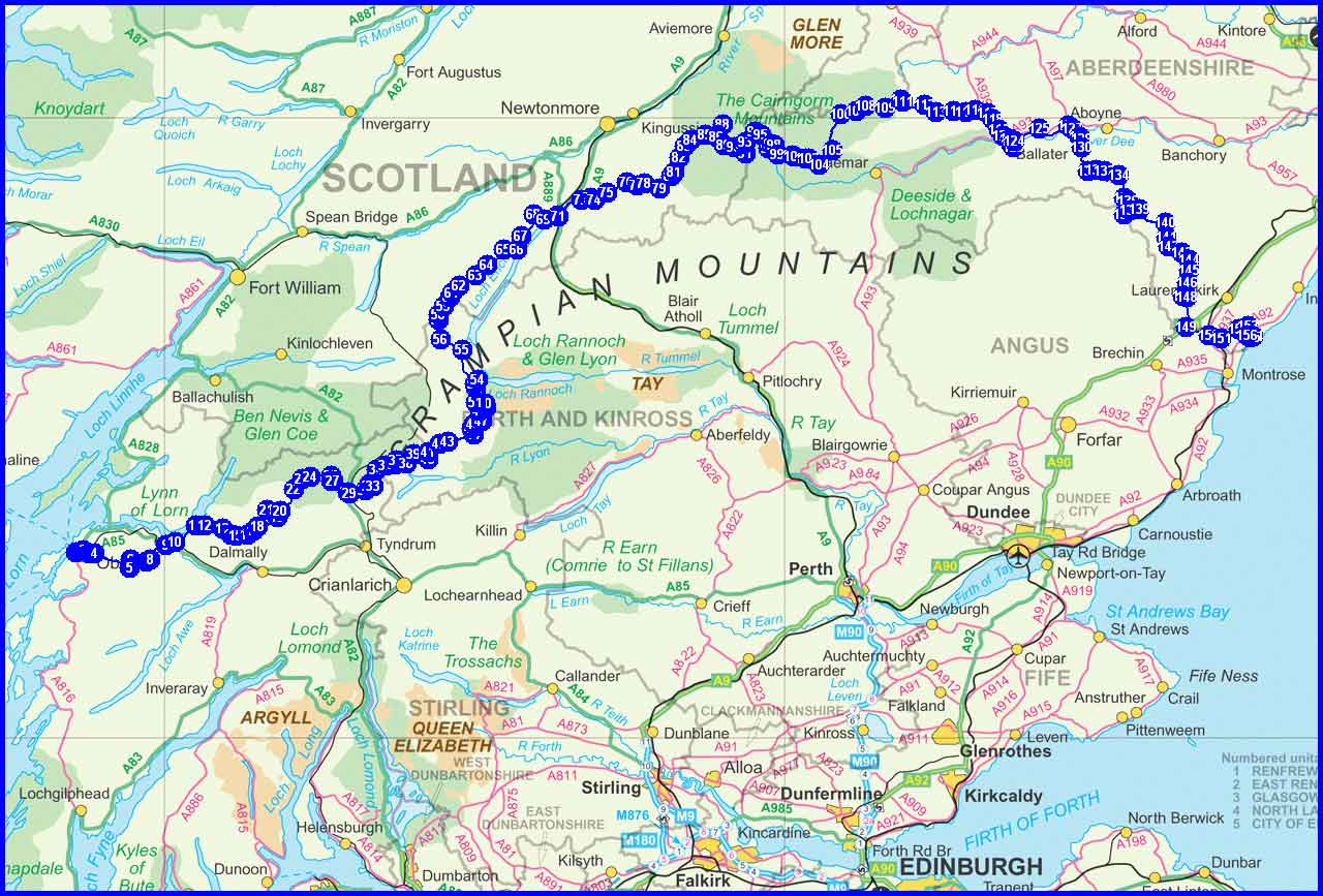
Planned Route and Estimated Statistics
(M) = Munro
(C) = Corbett
(G) = Graham
(Ma = Marilyn)
Day 1 - Friday 13 May
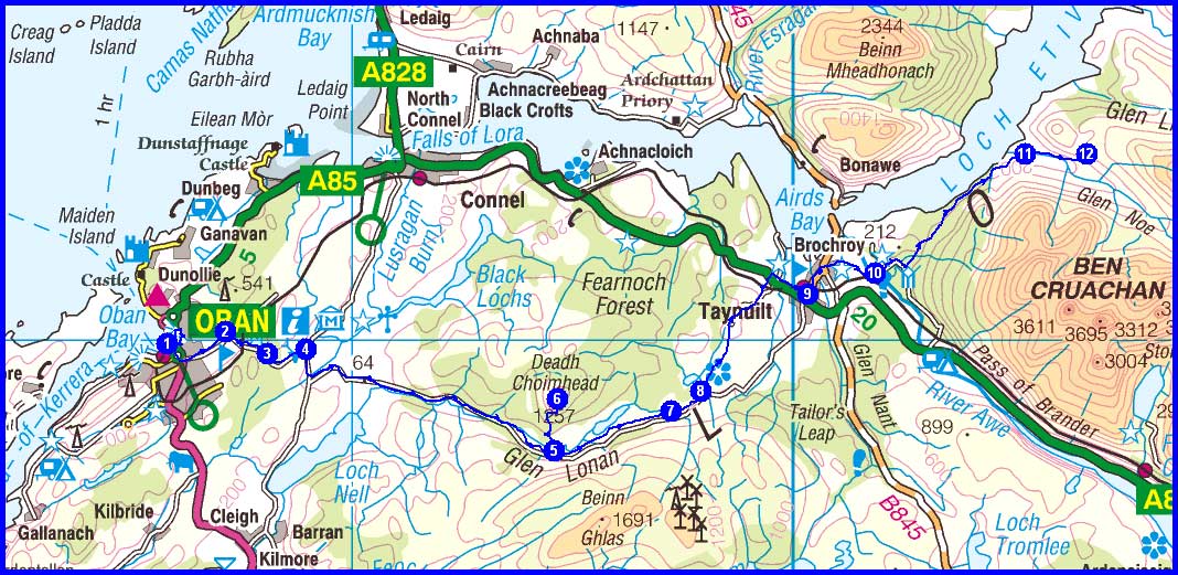
1 OBAN > Heritage Wharf > McCaig’s Tower
4 Barranrioch
5 Clachadubh
6 Deadh Choimhead (Ma) (there and back)
8 Barguillean Farm > Balindore
9 Taynuilt > Brochroy > Inverawe House
11 Glennoe
12 Creag an Fhithich
Plan
33 km
1220 metres ascent
12.75 hours
(1 Marilyn)
Day 2 - Saturday 14 May
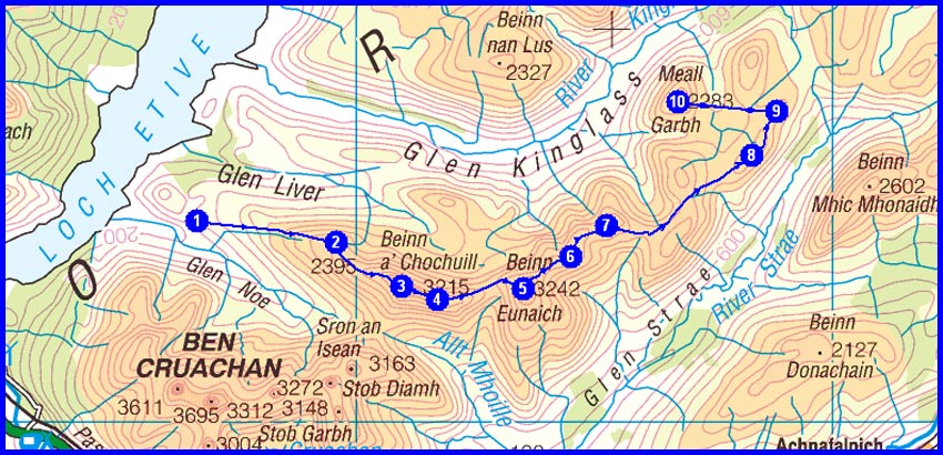
1 Creag an Fhithich
2 Aonach Breac
3 Beinn a’ Chochuill (M)
5 Beinn Eunaich (M)
7 Meall Copagach > cross Lairig Dhoireann
8 Beinn Larachan
9 Meall nan Uan > wild camp in this grid square >
there and back to
10
Meall Garbh (G)
Plan
19 km
1815 metres ascent
10.5 hours
(2 Munros)
(1 Graham)
Day 3 - Sunday 15 May
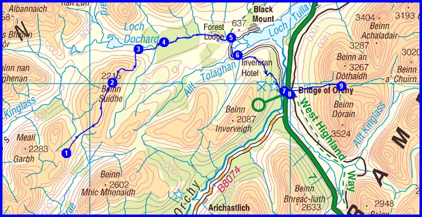
1 Meall nan Uan
2 Beinn Suidhe (G)
3 Loch Dochard
5 Victoria Bridge > Màm Carraigh
7 Bridge of Orchy >
Coire an Dòthaidh
9 Wild camp at head of Coire a’ Ghabhalaich
Plan
20 km
1109 metres ascent
9.0 hours
(1 Graham)
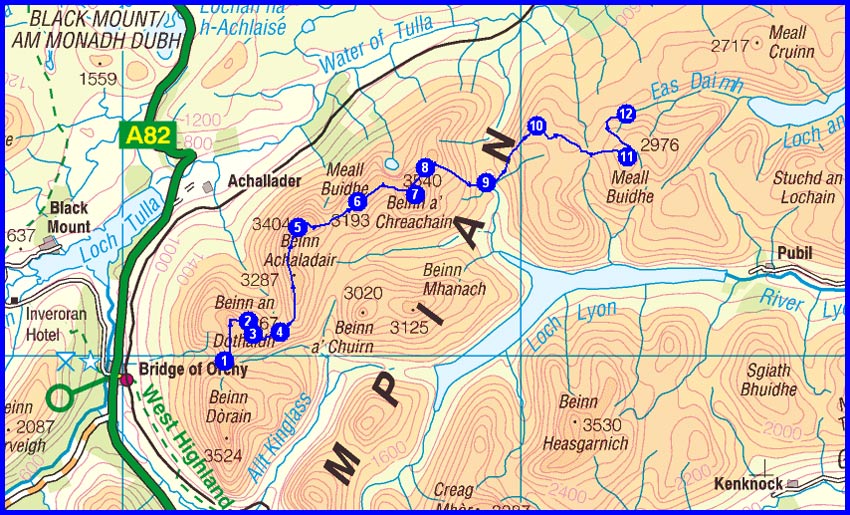
Day 4 - Monday 16 May
1 Coire a’ Ghabhalaich
2
Beinn an Dòthaidh (M)
5
Beinn Achaladair (M)
7
Beinn a’ Chreachain (M)
10 Creag Mhòr
11
Meall Buidhe (C)
12 Wild camp at head of Gleann Daimh
Plan
18 km
1639 metres ascent
10.25 hours
(3 Munros)
(1 Corbett)
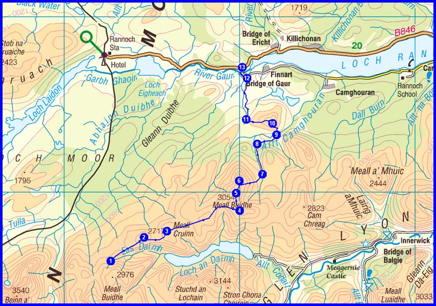
Day 5 - Tuesday 17 May
1 Head of Gleann Daimh
2 Creag Riabhach
3 Meall Cruinn
5
Meall Buidhe (M)
6 Garbh Mheall
7 Allt Easan Stalcair
10
Leagag (Ma) > Meall Dubh
13 Bridge of Gaur
Plan
22 km
950 metres ascent
9.5 hours
(1 Munro)
(1 Marilyn)
Day 6 - Wednesday 18 May
1 Bridge of Gaur
2 1km along B846 > track initially NW > past Sròn na h-Oissin
3 edge of forest at NN 483 625 > WNW to Lochan Meoigeach
4 Meall na Meoig (C)
5 Sgòr Gaibhre (M)
6 Sgòr Choinnich
7 Meall a’ Bhealaich
8 Beinn a’ Chumhainn
9 Bealach Cumhann > Bealach Dubh
11 Wild camp ~ NN 503 745
Plan
25 km
1589 metres ascent
11.6 hours
(1 Munro)
(1 Corbett)
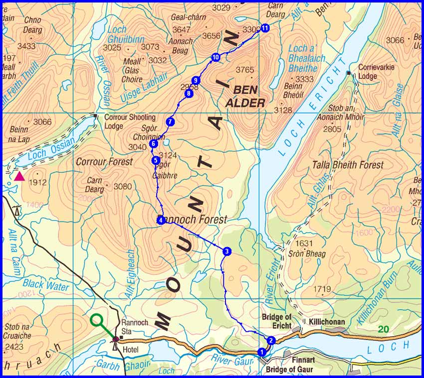
Day 7 - Thursday 19 May
1 Bealach Dubh
2 Culra Lodge > path to east of Allt a’ Chaoil-rèidhe
4 Ben Alder Lodge
5 Meall Cruaidh
6
The Fara (C)
7 An Tochailt
8 Dalwhinnie > aqueduct
10 Dam
11 Loch Cuaich
Plan
28 km
843 metres ascent
10.75 hours
(1 Corbett)
Day 8 - Friday 20 May
1 Loch Cuaich
3 Meall Chuaich (M) > Carn Thòmais > contour around Druim an t-Seilich
6 weir at Allt Bhran
7 Allt na Cuilce
9
Carn Dearg Mòr (C)
10 Carn Dearg Beag
12 Bridge S of Stronetoper
13 Allt Fhearnagan
Plan
27 km
1385 metres ascent
11.6 hours
(1 Munro)
(1 Corbett)
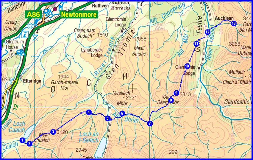
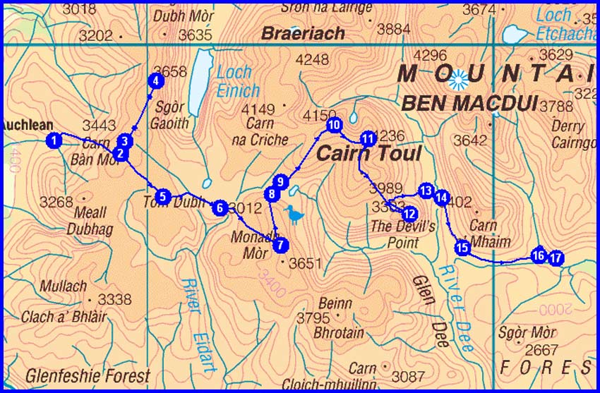
Day 9 - Saturday 21 May
1 Allt Fhearnagan
3 Carn Bàn Mòr > optional there and back to
4 Sgor Gaoith (M)
3 Carn Bàn Mòr
5 Point 957 E of Mòine Mhòr
6 Tom Dubh
7
Monadh Mòr (M)
10
Sgor an Lochain Uaine (M)
11
Cairn Toul (M)
12
The Devil’s Point (M) > Coire Odhar
13 Corrour Bothy
16 Luibeg Bridge
17 Glen Luibeg
Plan
29 km
1764 metres ascent
13.6 hours
(5 Munros)
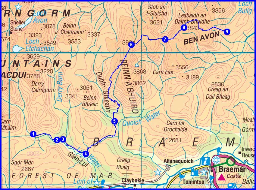
Day 10 - Sunday 22 May
1 Glen Luibeg
3 Derry Lodge > Glen Lui
4 Path over Clais Fhearnaig
5 Glen Quoich
6
Beinn a’ Bhuird North Top (M) via An Diollaid
8 Ben Avon – Leabaidh an Daimh Bhuidhe (M) > Clach Choutsaich
9 Carn Drochaid
Plan
26 km
1328 metres ascent
11.2 hours
(2 Munros)
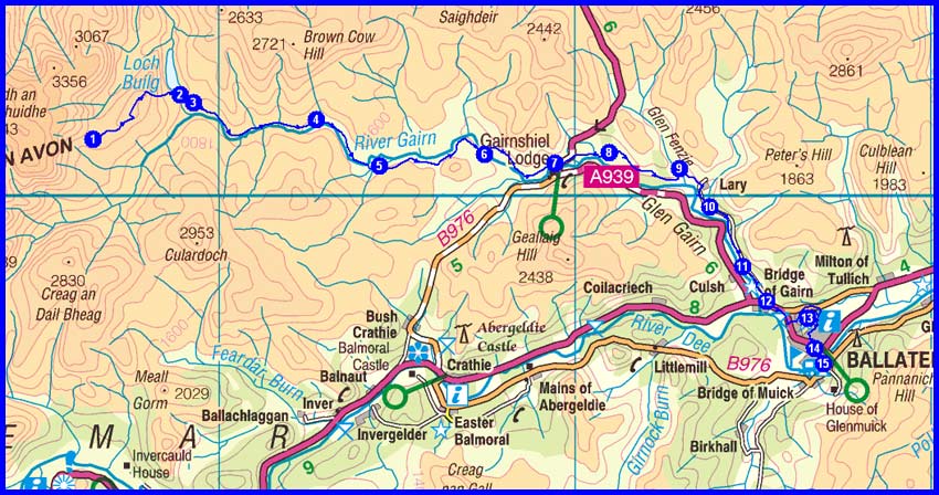
Day 11 - Monday 23 May
1 Carn Drochaid > Carn Dearg
2 Loch Builg
4 Corndavon Lodge
5 Daldownie
6 Tullochmacarrick
7 Gairnshiel Lodge
8 Tomnavey
9 Inverenzie
10 Morven Cotts
12 Bridge of Gairn
13
Craigendarroch (Ma)
15 Ballater Camp Site
Plan
31 km
693 metres ascent
11.5 hours
(1 Marilyn)
Day 12 - Tuesday 24 May
1 Ballater > cycle route
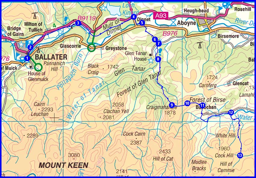
4 Dinnet via Cambus o’ May and Muir of Dinnet
5 Oldhall
6 Belrorie
8 Glen Tanar House > Firmounth Road
10 Hill of Duchery > Ballochan
12 Burnfoot
13 Water of Aven
Plan
33 km
931 metres ascent
11.9 hours
Day 13 - Wednesday 25 May
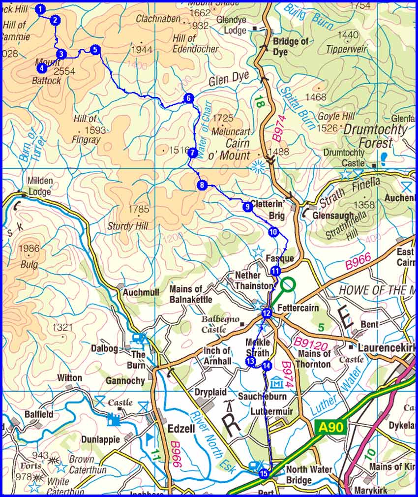
1 Water of Aven
2 Cock Hill
4 Mount Battock (C) (there and back from track) > Burn of Badymicks
6 Charr
7 Water of Charr
8 Hound Hillock
10 Arnbarrow
11 Craigmoston
12 Fettercairn
13 Meikle Strath
14 Bogmuir
15 North Water Bridge
Plan
35 km
764 metres ascent
12.6 hours
(1 Corbett)
Day 14 - Thursday 26 May
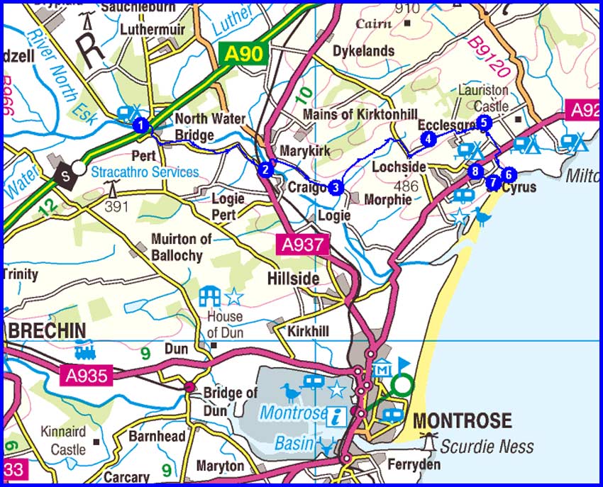
1 North Water Bridge > Gallery
2 Marymill
3 Canterland > Mill of Criggie > Snadon
5 Mains of Woodstone
6 Nether Woodston > beach at NO 756 648
Then return to 8 St Cyrus > bus to Montrose
Plan
16 km
268 metres ascent
5.4 hours
(An easy day at last!)
2011 Plan
Total Distance 365 km (228 miles)
Total Ascent 16310 metres
Time 152.2 hours including stops
15 Munros
5 Corbetts
2 Grahams
3 Marilyns not included above
NB Timings are based on 3.5 kph, plus an hour for each 500 metres of ascent and another hour for each 1000 metres of descent. This is realistic in the mountains but very conservative at the start from Oban and on the approach to Montrose.
| Actual | 2010 (M solo) | 2009 (S + M) | 2008 (S + M) | 2007 (M solo) |
| Total Distance in km (miles) | 347 (217) | 333 (208) | 323 (202) | 343 (214) |
| Ascent in metres | 15,500 | 12,400 | 12,544 | 12,942 |
| Hours taken including stops | 136 | 118 | 112 | 113 |
| Munros | 2 | 13 | 16 | 2 |
| Corbetts | 16 | 1 | 3 | 8 |
| Grahams | 4 | 3 | 1 | 2 |
| Marilyns not included above | 1 | 0 | 0 | 1 |
| Actual | 2011 (Martin) | 2011 (Mike) | ||
| Total Distance in km (miles) | 350 (219) | 333 (208) | ||
| Ascent in metres | 12,130 | 9,395 | ||
| Hours taken including stops | 115 | 115 (approx) | ||
| Munros | 5 | 2 | ||
| Corbetts | 3 | 2 | ||
| Grahams | 2 | 1 | ||
| Marilyns not included above | 3 | 0 |