Stats
Day 1 - Friday 11 May
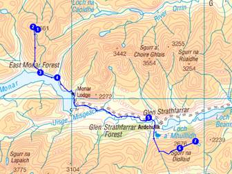
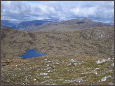
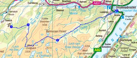
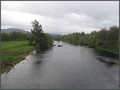
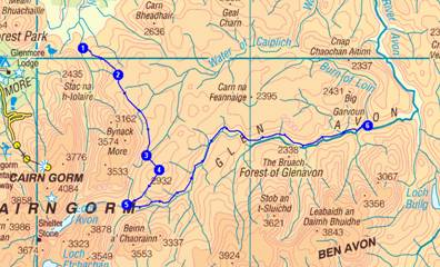
1 Strathcarron – River Taodil – 2 pass to N of Loch an Laoigh – 3 Sgurr na Feartaig – 4 Bealach Bhearnais (wild camp)
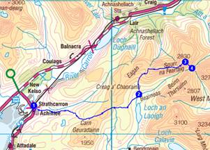
Plan
16 km
1180 metres ascent
7.7 hours
(1 Corbett)
Actual
19 km
1412 metres ascent
7.4 hours
incl 0.5 hr stops
(2 Corbetts)
Day 1 - As planned plus Beinn Tarsuinn. Lovely fine morning after a sumptious breakfast. Light rain after 1.30. Cloud and snow flurries above 850m. Three tents at this col at 600m. The others are 'baggers'. Many deer nearby. Walked with Alan Kay for a while but mostly alone. Good views to Torridon.
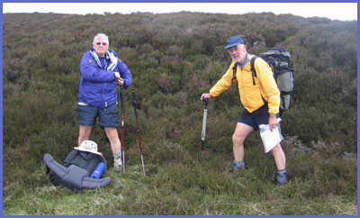
Details from postcard: After all the planning, at 9.30 the time to sign out and head along the thin blue line eventually arrived. Left Strathcarron to the familiar "cuckoo" of an unseen bird. Soon encountered my first 'misplacement' but contoured back to the 'line' and chatted to 66-year old Alan Kay for a while. Headed off up Sgurr na Feartaig. Adders, frogs and many deer. Bealach at 600m - good camp spot. Then packless up Beinn Tarsuinn. Too much food! Many deer here.
Day 2 - Saturday 12 May
1 Bealach Bhearnais – 2 Beinn Tarsuinn (packless) – 3 Pollan Buidhe – 4 Ruin beyond Glenuaig Lodge - 5 Torran Ceann Liath – 6 An Sidhean – 7 Wild camp at high Lochan
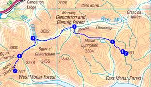
20 km
1300 metres ascent
9.0 hours
(2 Corbetts)
Actual
23 km
1220 metres ascent
9.2 hours
incl 0.7 hr stops
(1 Munro,
1 Corbett)
Day 2 - As planned plus Maoile Lunndaidh 1007m + 6km of tomorrow's route to camp by Loch Monar at point 4 (see day 3). Fine morning but rain pm. Cloud base 1100m. Only TGOC people seen were Pauline - in trouble with bad leg - and Bernie (super hero) Marshall. Lots of baggers this morning but saw no one this afternoon.
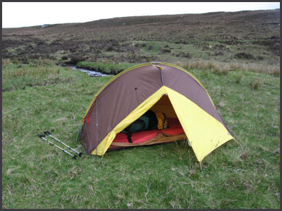
Camping alone in rain at 200m. Wet feet now dry and cosy. Going well.
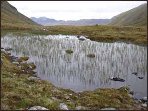
Details from postcard: I had already done the first 4km to today's route yesterday, so had an easy first 2 hours, along good paths. Bumped into Bernie and Pauline very briefly but all others were May weekend baggers. Saw no one at all, all pm! Very strange being part of this close knit fraternity of TGOCers but not seeing anyone! There are 300 others around somewhere. Anyway, just as well no one else wanted to camp here. From a distance it looked like a football pitch of nice sites. All bog! Except one small patch of 'less bog' on which I am very comfy. The rain has eased and I'm about to tuck into chicken noodle soup and my last pack of frankfurters. The food mountain is growing! Lots of milkwort and lousewort. No midges!
Day 3 - Sunday 13 May
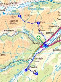
1 High lochan - 2 An Sidhean – 3/4 - by Loch Monar - Monar Lodge – 5 cross River Farrar – 6 Sgorr na Diollaid – 7 Loch Meall a Mhadaidh (wild camp)
21 km
1100 metres ascent
9.1 hours
(1 Corbett)
Actual
19 km
1153 metres ascent
9.0 hours
incl 1.5 hr stops
(1 Corbett)
Day 3 - A fine, cool day. Planned route plus 3.5km towards Carn Gorm, so bit ahead of schedule.
Easy first 8km with Alan Kay then alone over very rough ground over boggy, haggy Corbett to poor camping spot. So continued to camp at 540m overlooking tomorrow's route. Very cosy. Sun is shining and dinner is on. This is the life. New sealskinz = nearly dry feet. Still no phone signal.
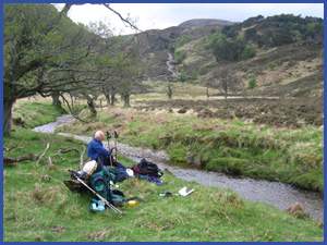
Details from postcard: Overnight rain eased towards morning but left a covering of snow above 800m. Managed some washing before setting off at 8.20. Alan Kay appeared and I spent 3 hours chatting to him before leaving him to 'low level' to Cannich. My route after the first 8km with Alan was very rough and pathless. Not unexpectedly the only inhabitants were deer and birds. Planned campsite was early and boggy, so I continued to below Carn Gorm. Have quite a nice pitch in deep heather. Need Sue to help out with the Angel Delights, which are rather lumpy! TGO fleece is excellent. Pasta and tuna has gone down well but Cannich's shops won't do very well out of me tomorrow - have surplus provisions. Found a big antler yesterday and a deer skeleton today. A fine, sunny evening.
Day 4 - Monday 14 May
1 Loch Meall a Mhadaidh – 2 Carn Gorm – 3 Cannich (re-supply) – SW to 4 Guisachan – 5 Loch na Beinne Moire (wild camp)
19 km
600 metres ascent
7.7 hours
(1 Graham)
Actual
20 km
697 metres ascent
7.3 hours
incl 1.0 hr stops
(1 Graham)
Day 4 - Finally got phone signal on Carn Gorm and spent time texting before rough descent to Cannich. Reported in to friendly Robin at TGOC control and booked ferry for Wednesday. Easy walking after that. First along road with a jogler (Ed - what is this?)* who is 71. My mates are getting older! Leave him and follow nice tracks through forest then moorland. Briefly T-shirt weather. Always a little further. Today 5km into tomorrow's long day. 2km beyond river Enrick crossing find superb campsite at 4.20pm. Tent up just before rain started. Now tucking into food mountain. No TGOC people seen today, but Maria says "hello Nick." She was at Strathcarron.
*John O' Groats to Lands End - M
Details from postcard: Woke at 4am to find tent stiff as an igloo, but by the time I got up at 7.30 the sun had melted and dried the ice. Leisurely departure by 9am and got to the easy, less boggy summit of Carn Gorm, a Graham, in half an hour. Spent another half hour there as I had the first phone signal of the trip. Then down to Cannich - very rough until old landrover track gained at 300m. From then on easy. Was supposed to resupply here but due to food mountain I made do with a Mars Bar (who can resist?) and a raw (not intended) banana. Spent a while with the 71 year old JOGLEer with a bad foot before heading off to the hills again. Planned camp was by a lake full of fishermen and no nearby obvious camping so continued 5km on tomorrow's route, eventually stopping at this idyllic spot. Intermittent rain. Lots of grub (quite hungry tonight) and an early night.
Day 5 - Tuesday 15 May
1 Loch na Beinne Moire – 2 River Enrick – 3 Loch Aslaich (via Balmacaan Forest) - 4 Drumnadrochit (Borlum Farm Campsite)
27 km
580 metres ascent
10.3 hours
Actual
24 km
414 metres ascent
7.0 hours
incl 1 hr stops
Day 5 - No peaks whatsoever! The Balmacaan Forest - a 500m plateau of bog squidging desolation. Not a tree in sight. Three hours to do 6km. Rest of the day was on nice paths. Am the only tent at Borlum. Nobody seen all day till Drumnadrochit. Lovely weather, T-shirt all day. Gas and food replenished as planned. Clothes and self washed and dried. Now to find a phone signal, restaurant, and some other TGOCers!
Details from postcard: Late last night (7.45) two elderly gents strolled past saying they were continuing for another hour! Since then, I woke at 1.30 to find tent like a board. 0 degrees inside so trousers needed. By 7.30 it had thawed so I rose to a sunny day. Easy walk up to reservoir with strange three storey building. Then 6km bog squishing across Balmacaan in the bootprints of Alan Kay. No one seen all day. Afternoon (arrived here 3.45) spent on lovely forest paths with a myriad of flowers and chaffinches. The broom is bright yellow everywhere. Recovered my gas cylinder from the Post Office (ordered, not posted!) and strolled up to Borlum. Food parcel is here, and as I am the only camper I have freedom of the washroom. Decided on £3 for an industrial drier, so washed everything! Start from the jetty at Urquhart Castle tomorrow morning, in a boat.
Day 6 - Wednesday 16 May
Borlum Farm to Temple Pier, Drumnadrochit – ferry to 1/2 Inverfarigaig – 3 Newlands – 4 Dunmaglass Lodge – 5 lunch hut at end of track - 6/7 Land Rover tracks - 8/9 River Findhorn (wild camp)
30 km
1200 metres ascent
12.0 hours
Actual
31 km
1211 metres ascent
9.0 hours
incl 1.5 hr stops
Day 6 - Saved 3km by catching ferry from castle pier. Ferry is a focus for TGOCers. Ten on the ferry. We soon became a group of 4 and I walked with Bob and Rose from backpackinglight.co.uk all day. Nice to have company for a change. Even did a podcast interview with Bob. Mainly roads and good tracks today - gave me two blisters but feet dry and a superb flat camping spot with B and R 3.5km into tomorrow's route at point 2. They let me test some of their dehydrated food - excellent! Cloudy with light rain at times, less than expected. Warmer.
Details from postcard: Quite a long day, but with company it seemed short. Spent last night in the Fiddlers Inn in the good company of John Burt (68, my mates are getting younger!) and a fine meal. Bob and Rose hid themselves in a corner for their 25th wedding anniversary meal. Gordon and his boat arrived 8.20 at Castle pier and I was suddenly in the company of 9 other TGOCers! At Inverfarigaig we dispersed, and I walked with Bob and Rose all day, and Ian Cotterill for a while. Mainly tracks and roads other than a 3km (one and a quarter hours) high haggy but fairly dry section in the middle. Had lunch in a hut with Klaus and Humphrey, two characters of the challenge. Now at a superb site with Bob and Rose in unexpectedly fine weather, lapwings and oystercatchers noisy above. A wide open vally - the river Findhorn. Still too cold to eat out - shouting between tents..... loads of deer nearby. No ticks here, but B & R have lots of bites.
Day 7 - Thursday 17 May
1 River Findhorn – 2 bridge before Coignascallan – 3 river crossing - 4 Creag Bhreac - 5 end of track - 6 start of track - 7 River Dulnain in the vicinity of Red Bothy (wild camp)
15 km
500 metres ascent
5.8 hours
Actual
9 km
416 metres ascent
4.5 hours
incl 0.8 hr stops
Day 7 - A restful day. Waved off Bob and Rose at 8am. Leisurely departure from lovely valley at 9.30. Good track with river crossings. Good camping spot. This is half way day - 146km done, 193km to go. Half way?! Plenty of wildlife today including hares but not a single other human.
Details from postcard: Hello there, Phreerunner here (Ed: I'm a tent). Since I'm integral to this adventure I'd better tell you a bit about myself. I'm about 25 years old, which is middle aged for one of my kind, but unlike my owner I haven't gone grey in that time. My brown hair is as glossy as ever. My parents were called Phoenix but sadly I'm an orphan and have no known living relatives. I did once suffer some broken bones due to a careless custodian (Ed: I guess that might be me - the pole snapped in high wind on the Isle of Skye, when I wasn't actually in it!), but a short spell in hospital sorted out that problem and renewed my damaged visor and cured my haemorrhoids. Last night I went to sleep early and had a lie in, so by the time I left this morning I had dried out nicely. I even had my bottom wiped! I'm now on a lovely flat piece of grass above a stream confluence. The sun is shining and the birds are twittering. I'm enjoying this trip as I only have one meal every night, whereas latterly I've been having two, and whilst that makes my stomach very cosy, it does cause some indigestion. (Ed: This is a reference to both Martin and I sharing the tent - it's a squeeze but possible for a short, lightweight backpack - it took me a while to work it out!). So here I am having a great time out here in the wilderness.
Day 8 - Friday 18 May
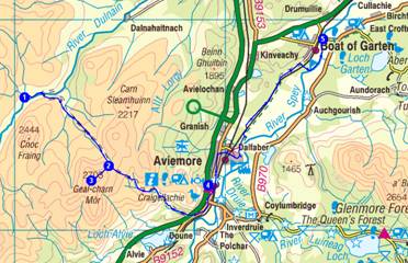
1 by Red Bothy – 2 Allt Ghiuthais - 3 Geal-Charn Mor (packless) – 4 Aviemore – Speyside Way - 5 Boat of Garten (Fraoch Lodge)
27 km
650 metres ascent
10.2 hours
(1 Corbett)
Actual
29 km
681 metres ascent
8.7 hours
incl 1.7 hr stops
(1 Corbett)
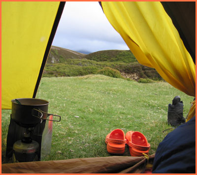
Day 8 - 8.15am start on an increasingly breezy, showery day. But good visibility with Cairngorms clear. Environs of red bothy were heaving with DofE kids so last night's camp spot was a good decision. Burma road - the track to Aviemore - was deserted. Easy Corbett en route. Horrible Aviemore. Lunch in a gale on an interminable housing estate. Then pleasantly along the Speyside way - Janet Jardine joined me for the last hour to Froach lodge, during which we enjoyed a coffee and cake stop. Nice to have company for a while after walking alone for 2 days.
Details from postcard: Rain in the air all day, but rarely very wet. Good tracks all day made the 29km, 681m ascent easy. The Corbett Geal Charn Mor was very easy. Got first phone signal for 3 days there. No challengers seen, but 'control' assures me I'm not a backmarker! Limited call to Sue on mobile due to excavator next to all of Aviemore's public phones. Luckily, Fraoch has a charger, now re-powering said phone, and I'm sitting in front of a roaring fire awaiting Rebecca's 7.30 meal. Washing is done, beard is gone, and all is well with the world. And Bob has booked me in for the meal next Thursday. The food parcels have arrived, the cards are posted, etc, etc. Late news: Investigative reporter Janet texts to inform me that Darren appears to have been hospitalised and repatriated. Oh dear. His blog and phone remain silent.
Day 9 - Saturday 19 May
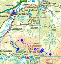
1 Boat of Garten – 2 Badaguish – 3 Craiggowrie – 4 Meall a’ Bhuachaille – 5 Ryvoan Bothy – 6 path junction - 7 Bynack Stable (wild camp)
22 km
1000 metres ascent
9.1 hours
(1 Corbett)
Actual
24 km
930 metres ascent
7.5 hours
incl 0.8 hr stops
(1 Corbett)
Day 9 - 'Memory man', reeling from the news of Darren's problems - no details yet - leaves the comfort of Fraoch lodge sans poles. This adds 5km of road walking to the day. Once off the road it is pleasant forest tracks, but always with rain in the air without really being wet. After a damp al fresco lunch I head out of the forest and up Craiggowrie. Meet first walkers since I last saw Bob and Rose on Thursday morning. The 4km broad ridge to the Corbett is easy but windy. Windy, yes, windy. Drop down to Ryvoan Bothy and miss Judith Barnes (TGOC no 20, I am number 19) by 5 minutes. So that's 3 days without a sighting! Set up camp nearby as it looks better than further on. Nice grassy site. Also I am curious to know what happened to Darren. I would guess he got exposure in his tarp but that's pure conjecture.* (Ed: Darren had to be helicoptered to hospital after suffering severe vomiting. Phil alerted rescue services - hero. For full story, see Darren's blog. Look for May 16: TGOC - The missing days.)
*I'm glad to be proved wrong on that - M
Day 9 later - A non-TGOC man has just pitched next to me and is snoring like a pig! And I thought I had been well behaved today! Ho hum
Details from postcard: Not bad campsite near Ryvoan bothy. Just found good spot to use the trowel again. Keeping regular! Once here, paid particular attention to the guy lines as it's a bit breezy, but now down at 350m so not too bad. Tea then goes on and is drunk whilst blog is composed. Then soup is soaked whilst blog is sent. After that the pasta 'n' sauce goes on whilst this card is written. Then the tuna is added and there is more simmering whilst the diary entry is made. If that's finished by the time the Angel Delight is mixed, a chapter of Rum Doodle is read whilst that sets. A hot chocolate is then the final act before bed. All very leisurely and relaxing after a long day's walk. I should have learnt; I have another food mountain. At least I can carry it!
Day 10 - Sunday 20 May
1 Bynack Stable – 2 by An Lurg - 3 head of Glasath - 4 Creag Mhor – 5 Fords of Avon – 6 Bridge over River Avon (wild camp)
24 km
900 metres ascent
9.7 hours
(1 Corbett)
Actual
24 km
945 metres ascent
8.3 hours
incl 1 hr stops
(1 Corbett)
Day 10 - 3am - all hell lets loose. We have pitched in the centre of a nocturnal jousting arena. Strutting, hissing, gurgling, wings facing back, white tail feathers bristling, the black grouse are at it, lekking. Watch, fascinated. The only way to stop the cacophany is to get out and shoo them. Do this about 10 times over the next two hours. Sleep in. Soon say bye to Paul, the itinerant snoring Scotsman pitched next to me. Its another 'rain in the air' day, but the tops are clear and I even wear a t-shirt for a while. Nice pimply Corbett - lunch on the summit. Pass a bothy where Judith went through roughly 4 hours earlier. Am 2km short of today's target, but as usual am distracted by nice camping spot. Anyway I had sore feet and bum - not sore now! Cosy in tent. Nobody seen today apart from Paul. The Avon valley: nice but long! Sorry about today's verbosity - have some long days ahead with fleshpots at their end so future messages should be shorter.
Details from postcard: Am camped on a nice grassy spot by the River Avon at NJ 136 062 and 469 metres according to my GPS, which is good for pinpointing my camping spots, if nothing else. The pressure is still rising so hopefully the good visibility will continue. It's very quiet here apart from the distant roar of the river. There were lots of entries from Challengers in Faindouran Bothy, passed mid-afternoon, but I'm at least a day behind the main group. Judith Barnes is camped just a few km ahead according to her bothy entry, so if I start early I may meet her tomorrow! So I'll now settle down to a good meal and an early night.
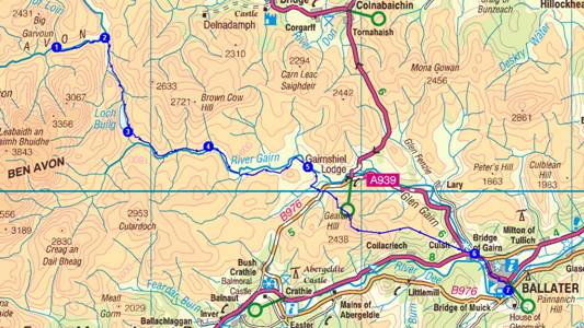
Day 11 - Monday 21 May
1 By River Avon – 2 Inchrory - 3 Lochbuilg Lodge - 4 Corndavon Lodge – 5 Tullochmacarrick - Geallaig Hill - 6 Bridge of Gairn - 7 Ballater (campsite)
32 km
850 metres ascent
12.3 hours
(1 Graham)
Actual
35 km
921 metres ascent
10.0 hours
incl 1.5 hr stops
(1 Graham)
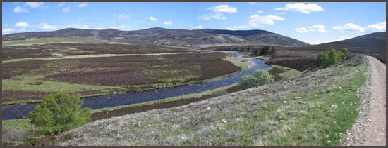
Day 11 - Packed away frozen tent and set off at 6.30. Soon passed a tent that proved not to be Judith, and crossed a bridge with a choice of routes. I chose the 6" girder with only 6 feet to fall into 2 feet of water. It bounced in the middle. I crossed like a disabled limbo dancer. Lovely day despite the cool breeze. Walked down long pretty Scottish valleys with lapwings and oystercatchers. Then up an easy hill with a devilish descent to Ballater, where after five days I have finally met some challengers, too many to name but including the elusive Judith, Doug Bruce and Heather T-S.
Details from postcard: A lovely walk today, with flapping Lapwings and whistling Oyster Catchers for company all the way. A sociable day too. My first brew was at a disused bothy where two rustic cyclists (old bikes with drop handlebars at the end of a very rough track) who didn't believe in stoves were boiling water on a grubby wood fire. They fed me ginger cake. At least my fleece now stinks of wood smoke rather than sweat! Then on the approach to Ballater I met a Challenger! Sue Dunbar - the first for 5 days. And there were LOTS at the campsite. I ate at the Glenaden Hotel where I joined Ellie Taylor, Derek Goffin, Peter Kenyon and Barbara Saunders (who has tendon problems). The meal was nice but I would have preferred a smoked salmon starter to the free pint of 80/- that replaced the forgotten dish. Then beers with Judith Barnes, Heather Thomas-Smith and Peter and Barbara. Doug Bruce is next to me on the camp site, where we have a solid enclave of one-man tents. Phreerunner seems unique, and some are curious.
Day 12 - Tuesday 22 May
1 Ballater – 2 path junction - 3 bridge E of Shiel of Glentanar, via Lach na Gualainn – 4 Mount Keen – 5 Braid Cairn – 6 Hill of Gairney – 7 small col - 8 Cock Cairn – 9 Hill of Cat – 10 by Gannoch - 11 Tampie - 12 Fungle Road (wild camp)
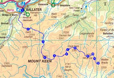
27 km
1500 metres ascent
12.0 hours
(1 Munro)
Actual
27 km
1497 metres ascent
9.7 hours
incl 1.3 hr stops
(1 Munro)
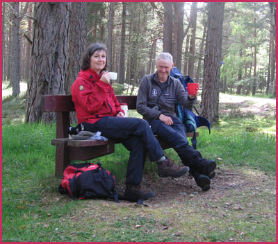
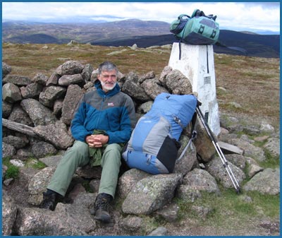
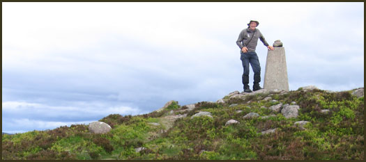
Day 12 - After a good night out with new friends I was away by 8am. But not before Waggy, who we encountered in the Alps last year (he is a TGOC stalwart) paid our flotilla of tents a visit. He was his usual chipper self, if a bit haggard. We were pleased to see him as he was last reported trying to pitch camp in a ditch by a main road, and it was rumoured he was one of 19 people who have currently failed to report in on time. The walk up Mount Keen was in the good company of James Greig and Mick Guest, and superb views towards Lochnagar. We made it in under 4.5 hours. The ever speedy Heather T-S joined us on the summit with five others. Quite a crowd. They left for the fleshpots of Tarfside whilst I plodded the broad summits towards the ever nearer sea. Dry feet! - not so sore today. Route mostly over trackless heather so hard going. Found an adequate if tussocky and sloping site for the last wild camp, just north of col, with good water.
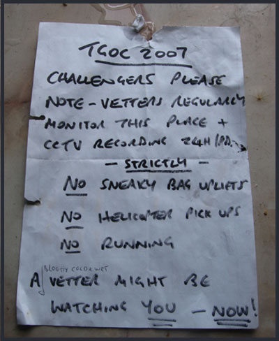
Details from postcard: Whyever do 300 people flog up and down hills with sore feet and itchy arses, with leaky boots and heavy rucksacs, on boggy paths, with smelly clothes and sunburnt necks, often all alone, camping on boggy slopes with ticks and midges, eating dried food in cramped conditions where their only room is lounge, bedroom, dining room, storage cupboard and even the lav (with portable cistern of course!)?
Because they love the solitude, the occasional cameraderie, the fresh air and the flora and fauna that can be so, so close, the cosy tent and the soft bed, idyllic camping by gurgling streams, the sweet smell of the pine forest and the warm breath of sun on the tent, meeting new friends and renewing old acquaintances, sharing freshly brewed tea and coffee, beer and whisky as well, and of course the pleasures of Angel Delight and hot chocolate before bed......
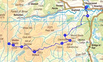
Day 13 - Wednesday 23 May
1 Fungle Road – 2 Mudlee Bracks – 3 Hill of Cammie – 4 Mount Battock – 5 Hill of Edendocher – 6 Clachnaben – 7 Airy Muir - Burn of Greendams – Cuttie’s Wood – 8 Cuttieshillock – 9 Feughside Inn (campsite)
24 km
620 metres ascent
9.0 hours
(1 Corbett)
Actual
24 km
640 metres ascent
7.9 hours
incl 1.9 hr stops
(1 Corbett)
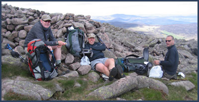
Day 13 - Up at 6.30 to catch up with diary. Then continue slog over various tops in a selection of heathers alongside the double electric fence which kept saying "gockoo" to me. Finally left the fence at Mount Battock, where Graham Brookes, on his 18th challenge, suddenly appeared. Like me he has followed his planned route fairly precisely. He once didn't meet another challenger until the 13th day. And I thought 5 days was a lot! We set off in different directions. I head for Clachnaben - "a fine wee hill" according to Ian Shiel. It is. But still windy. Send texts and make Darren jealous (next year Darren). Then on down to the campsite on a lovely summery afternoon where Rob Patterson and Margaret Finch arrive at the same time. Fab meal at pub and Bill Strang and Martin Scoular arrive to round off a great day.
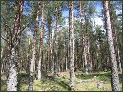
Details from postcard: After a nice sleep amongst cosy tussocks, I return to the Fungle Road col and bash on in the close company of '...eeeep ing' Golden Plovers to Mount Battock. Half an hour with Graham Brookes puts a spring in my step for the easier passage towards Clachnaben. Its conspicuous rocky outcrop is very windy on top, and I find it hard to find a place to brew up. Not much food left, so I jokingly send a text to Martin Scoular: "running out of food!". Also jest with Darren by text message - hope he has a sense of humour. The t-shirt and sun tan cream finally go on when I get into the trees out of the cold wind. It's an idyllic evening. Rob and Margaret are at the campsite and I join them for a superb meal at the Feughside Inn. Before that Bill Strang appears from Egypt (he had a meeting nearby) and we enjoy a pint and a chinwag. Then later Martin S turns up. More drinks, and embarrassingly, he has brought a whole box of food! (What a good friend...) I select a nut bar. Thanks Martin. So all in all a very enjoyable and sociable day.
Day 14 - Thursday 24 May
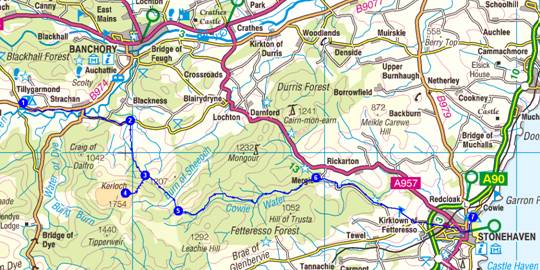
1 Feughside – Strachan – 2 Moss-side – S to 3 Glenskinnan – 4 Kerloch (packless) – 5 Fetteresso Forest – 6 Mergie – 7 Stonehaven – bus/train to Montrose (campsite)
35 km
800 metres ascent
10.3 hours
Actual
35 km
805 metres ascent
8.0 hours
incl 0.8 hr stops
(1 Marilyn)
Day 14 - Well, I am finally here at Stonehaven at 1pm after 14 days of fine walking in good weather. Twelve of those days I walked alone, but whilst that was enjoyable I met some great people as well. Thanks to everyone who has made this a memorable trip. Rob said last night that there is always a day before the end when you want it to finish. That didn't happen for me. After today's walk up Kerloch and striding out through the forest I've reached the sea and the walk has come to a natural and successful conclusion. I feel great. I think I could get addicted to this one. Now, Cinderella must not be late for the ball, so that's it for this year (subject to more cards and some photos going on this page next week. Ed: That's what Martin thinks - there is vacuuming, washing......etc!)
Details from postcard: N
Hello, this is Phreerunner. I am so pleased; last night I slept next to a long lost cousin, Phalcon. It was great. We had a lovely chat about old times.*
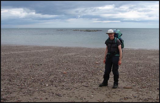
Up at the crack of dawn (4.15) to start walking at 5 am. It's a fine day and the sun is up at 5.30. A Yellowhammer hops along the hedge in front of me and some guinea fowl fly into a field. I eventually leave the road and soon enter forestry leading to the foot of Kerloch. The sun is shining weakly through high cloud. Stash my sac for a quick ascent of my last hill of this trip. It's well worth it (Rob P had his doubts). Good views back to Battock, and to a coast laden with sea fret. Then easy paths through the long Fetteresso Forest, and country roads, passing Margaret Fynney and Nan Lyle, to Stonehaven by 1 pm, for a photo on the beach taken by two Italian tourists. And then, back to Charlie Frazer's for a pot of tea and a shower, before heading to finish control at the Park Hotel, and 'The Ball'.
* I later discovered that Doug and Howard also have Phreerunners, so mine is not quite an orphan! - M
Thank you, Roger Smith, my vetter Ian Shiel, Charlie for looking after the car, Janet, Bill and Martin for taking the trouble to meet up with me en route, Darren for your company up to Stirling, others for their company on the way home, all those I met en-route - most of whom are mentioned above, Doug Cockburn for seeking me out at the end after not seeing me for nearly 40 years, those including Colin Tock who responded to my sometimes naive messages on the 'board', and everyone involved with making the event so enjoyable for a 'First Timer'. I can't wait for next year!
Thanks finally but most importantly to Sue, my webmaster and all other things, who had to go to work whilst I lived my Life of Riley; I am looking forward to her joining me next year, even if it does mean supplanting the Phreerunner with the characterless Nallo!
Total Distance
Total Ascent
Time
339 km
12780 metres
123 hours
343 km (214 miles)
12942 metres
113 hours including stops