Home
Day Walks
Sunday 9 December 2007
(Report)
A Circuit from The Roaches, via Lud's Church and Wincle
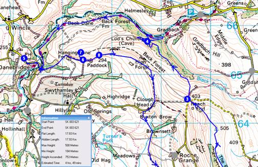
Meet in the spacious layby at SK 003 621 at 10.00 am for this 18 km stroll.
Route Summary
1->2->3->4->5->6->7->6->8->9->1
Instructions
NB The distance is the flat length to the
next Waypoint. Timing is based on Naismith's calculation of 5.00 Km/hour
and 600 Metres ascent adds an hour.
Overview
1 SK 003 621 Free Parking below The Roaches
1->2 0.79 km 106 metres ascent 20 mins
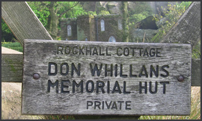
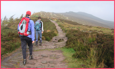
Go up the well used track and after a few 100m turn left up below the crags, passing the Don Whillans Memorial Hut. Continue through woodland past climbers on the crags, until a way up along a switchback path (short cuts allowed) takes you on to the ridge.
 |
 |
2 SK 7005 625 Summerhill
2->3 2.42 km 89 metres ascent 38 mins
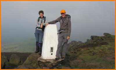
Continue NNW along the crest of the ridge, pausing at the 505m trig point, before descending to the road at Roach End where at weekends you may be lucky enough to find an ice cream.
 |
 |
3 SJ 995 644 Roach End
3->4 4.72 km 40 metres ascent 25 mins
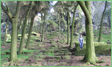
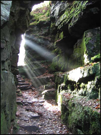
Cross the road and through the stile take another stile immediately to the right, to head downhill towards the woods of Back Forest. Do not take the path to Gradbach, instead head briefly upwards on the path signed to Lud's Church. After more lovely woodland a sign points left towards Lud's Church. Pass to the left of a 'Dangerous Cliff' sign before descending into the Church.
4 SJ 987 656 Lud's Church
4->5 4.67 km 148 metres ascent 1hr 11 mins
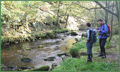
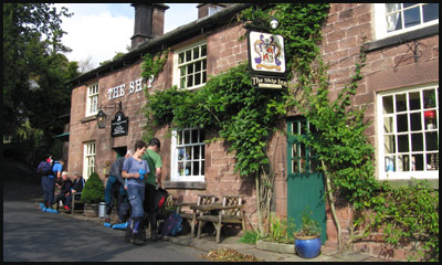
Go through the deep cleft, dripping with algae, and after a pond with stepping stones emerge at the lower entrance and turn left. At the first junction turn sharp right towards Gradbach. At the first opportunity, after a few 100m, go L down to the river to join a signed path by the River Dane, heading W to Danebridge. Continue along this path, through lovely woods and some more open areas, and past farms with horses, sheep and sometimes donkeys. Eventually reach the high bridge at Danebridge, where you emerge onto the lane and cross the bridge (good views) before strolling 200m up the lane to The Ship Inn. (See Note 1)
|
 |
5 SJ 962 653 The Ship at Wincle
5->6 1.48 km 111 metres ascent 29 mins
Turn L out of The Ship and go over the bridge (see Note 2) and past a few houses, where you turn left on a narrow path up and round the back of houses, past private woods on the right, to join another path from the left [alternative route - L immed after bridge then turn R to Hanging Stone]. Go up this path and into a sometimes boggy field, to a track near Hanging Stone Farm. Turn R and pass the farm to arrive at a concessionary path up Hanging Stone.
 |
 |
6 SJ 974 652 Path to Hanging Stone
6->7 0.20 km 42 metres ascent 7 mins
| A short walk up to The Hanging Stone is rewarded with a fine view. (See Note 3) |
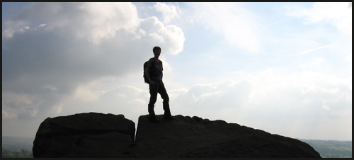 |
7 SJ 973 654 The Hanging Stone
7->6 0.20 km 0 metres ascent 2 mins
Return to the path junction.
6 SJ 974 652 Path to Hanging Stone
6->8 0.36 km 20 metres ascent 6 mins
Continue East to another path junction.
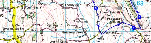
8 SJ 977 653 Path Junction
8->9 3.70 km 71 metres ascent 52 mins
Go straight along a gently rising track passing High Forest Farm before turning onto a tarmac track that leads to a minor road at Clough Head. Go along this road to the first farm on the left, Buxton Brow. Turn L into the farm then R towards the farmhouse, just before which a path L takes you into a field. You need to cross L over the obvious track leading S, and over a small stile into a field. In Oct 2007 there was lots of slurry here but we managed an incident free crossing into a field, on the far side of which an open gate led down into a small valley with woodland where the marked path crosses a small stream by a bridge. From here the path leads easily south to Greenhouse.
 |
 |
9 SJ 990 628 Greenhouse
9->1 2.27 km 127 metres ascent 40 mins
Continue down the tarmac lane for 10 minutes. Take a path to the left past the front of a house, where the road bears right. After a few metres turn left again on the signed path, heading up through fields to Pheasant's Clough Farm, from where the farm driveway leads back to the large lay by.
1 SK 003 621 Free Parking below The Roaches
Total trip 17.83km 754 metres ascent 4 hrs, 49 mins
Note 1:
The Ship Inn is believed to date from the sixteenth century. There are numerous stories associated with the pub, mainly concerning the name. It is presumed that a relative of Sir John Brocklehurst, who owned nearby Swythamley Hall, Sir Philip Brocklehurst, sailed with the explorer Shackleton on one of his many expeditions to the Antarctic, as an Assistant Geologist, although history states that he may well have been a paying guest. It was often thought that the sign on the Ship Inn related to the famous Endeavour, a 1914 expedition, but it depicts the Nimrod in Antarctic Ice. Others say that the Ship is named after another vessel, known as the Swythamley, which was owned by a close friend of the Squire, and that the pub was named in his honour. These days it is renowned for the fine real ales on sale, and a popular restaurant.
Note 2:
A crossing of the River Dane at Danebridge was first recorded in 1190, where it was known as Scliderford, meaning a slippery ford. In 1357, Sliderford Bridge was constructed, but was rebuilt in the seventeenth century, using stone. Unfortunately, this was washed away by floods in 1631 and replaced a year later by another, more sturdy, bridge. The present bridge dates from around 1869, and was funded by the two Counties of Cheshire and Staffordshire, with each paying £1,000 for its upkeep; materials being supplied by the Brocklehurst family, of Swythamley Hall, who were major landowners during the eighteenth century.
Note 3 :
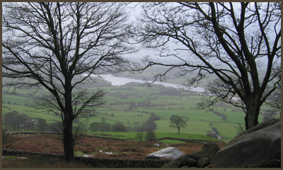
The Hanging Stone perches on the hillside like a giant fist, a sentinel overlooking Swythamley, on the Staffordshire side of the River Dane. Swythamley Hall stands in a fine park and was originally a mediaeval hunting lodge belonging to the Abbey of Dieulacres near Leek. The hall was granted to the Traffords by Henry VIII in 1540 and became their home and that of their successors, the Brocklehursts. Unfortunately the original house burned down in 1813, so the modern building is a rebuild dating from then.
The Brocklehursts had an adventurous history. One of them accompanied Shackleton to the Antarctic. The Hanging Stone bears a plaque to Colonel Brocklehurst, who was killed in Burma in 1942. A game warden in the Sudan, he started a private zoo at Swythamley when he returned to Britain, and during the Second World War the animals were released into the countryside because there was no food for them. The wallabies from the zoo survived and bred around the Roaches until the late 1990s. Sightings of them have surprised many walkers and climbers over the years.
The plaque reads:
“Lt. Col. Henry Courtney Brocklehurst. 10th Royal Hussars and Pilot in the Royal Flying Corps, 1916 - 1918. Game Warden of the Sudan. Born at Swythamley, May 27th, 1888. Killed Whilst On Active Service, in Burma, on Commando. June 1942.
Horses he loved and laughter, the sun. Wide spaces and the open air.
The trust of all dumb living things he won, and never knew the luck too good to share.
His were the simple heart and open hand, and honest faults he never strove to hide.
Problems of life he could not understand, but as a man would wish to die he died.
Now, though he will not ride with us again, his merry spirit seems our comrade yet.
Freed from the power of loneliness and pain, forbidding us to mourn or to forget.
Erected by his devoted brother – 1949”
There’s a second, earlier stone plaque at the foot of the stone:
“Beneath This Rock
August 1, 1874 was buried
BURKE
A Noble Mastiff
Black and Tan
Faithful as Woman
Braver than Man
A Gun and a Ramble
His Heart’s Desire
With the Friend of his Life
The Swythamley Squire"