Home
Evening Walks Report
Wednesday 30 June 2004
Evening walk from Edale
(main car park)
Here are details of the
proposed route and a map. The walk should take about 3 hours, but it can be
cut to 2 hours very easily if that is the consensus.
Call us on 07968 122170 if you are coming but running late.
Regards,
Martin and Sue
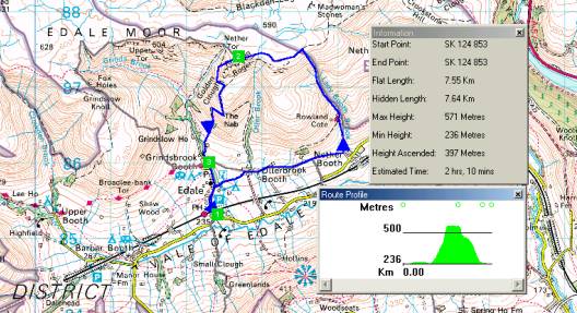
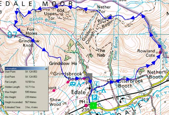
Edale Circuit
Route
Summary
1 -> 1
Instructions
1 (SK 124 853) Start at Edale pay and display Car Park.
1 -> 1 (10.58 Km) Walk up road to Edale and turn right
down track after Fieldhead Information Centre. Through farm yard and straight
on to next farm (Cotefield). Leave track to continue ahead on field path.
Bear right to cross a low bridge then a stile; here turn left up side of field
and bear right along path round top side of semi-wooded area.
Go in front of the YH buildings before curving left around the far end. Cross
a stile and ascend beside a stream. Continue up the clough until the path
is deflected left by a branch of the valley. Cross stream and continue climbing
in same direction as used coming up the clough. Keep to the left of the stream
bed. Just before the top of the moor, turn left along a wide path.
Continue along the moorland edge. Ignore paths to the left. When reaching
an eroded piece of stony, peaty ground bear off slightly to the right to cross
it. At the other side continue along the obvious path along the moorland edge.
(Unless deciding to shorten the walk by descending left down
Golden Clough to Edale.) Follow for 1.5
miles to the head of Grindsbrook, the deep valley on the left.
Here the path curves right, until it reaches a crossing point over the stream
bed on the left. On the other side turn left along the path above the deep
rocky gully. At the next deep gully curve around the top and continue on the
path with Grindsbrook still down to the left.
Continue along the edge of the moor, passing over the hump of Grindslow Knoll
before beginning the long descent to Edale. On reaching the village - via
the Nags Head - turn right down the road to the start.
On a sunny
evening after a wet day Sue and I found Andrew lounging in the car park.
Dave and Margaret
soon turned up and we set off on schedule with a minimum of gear. Dave knows
this area like the back of
his hand, but that didn't stop us (me) losing concentration and missing
the path after the low bridge.
After finding ourselves back by the main road, we walked up the road to
the Youth Hostel, which has
sprouted lots of adventure equipment - climbing wall, assorted high and
low level playgrounds. The main
building was being reconstructed so we couldn't walk in front of it. So
we found a way onto the hill past
various earnest leaders with attentive children.
At first there was a path above
the right bank (left hand side) of Lady Booth Brook. This soon petered
out by an orienteering marker, leaving us to slog our way slowly over rough
ground, eventually reaching
a path at the top of the slope - we even managed a bit of scrambling. This
was the roughest and steepest
(probably the only pathless) of our evening walks this year - a brutal introduction
for Margaret, who had
not walked with us before.
Hereabouts there were numerous
grouse, some with youngsters running around in the heather, and also
rabbits - some more alert than others.
There were lovely clear views
to the Mam Tor ridge and above Castleton (only the huge quarry chimney
was visible), with distant views towards Derby to the south west. Due to
the unseasonal weather, the
flask came out, after which we continued on to the 'Ringing Roger' area
(we didn't discover what
'Ringing Roger' actually consists of) before diverging from the planned
route to descend down to The Nab.
We passed a couple of big rocks near the summit from which we could easily
jump from one to the other
- a bit like an easy version of Tryfan's more challenging Adam and Eve.
Our chatty stroll continued on
the easy path down to Grinds Brook and the Nag's Head was reached
at 9.50pm. Despite the inappropriate music we enjoyed a drink before ambling
back down to the car park
on a pleasant night under a newly risen full moon.
Our route and statistics (timing based on 5kph plus an hour for each 600m
of ascent) are shown below.