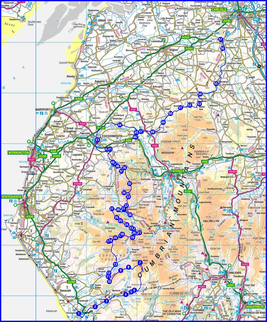
Route details:
Day1 Day2 Day3
Day4 Day5 Day6
Day7
Ravenglass to Dalston backpack 31 May to 7 June 2008
The
actual route is shown below:
Note the timings shown are based on 4 km/hour and
600 m ascent/hour, compared with
Naismiths formula which is 5 km/hour. Total time excluding stops may slightly
exceed these
estimates.
Note that steeper descents will take longer than estimated, but overall timings should be reasonably accurate.
The total distance was about 145 km (91 miles) [2007: 126km], with ascent of about 6227 metres [2007: 7000m] and a total estimated time,
excluding stops of 46 hours [2007: 43 hours] walking.
Top
Saturday 31 May
Rendezvous in Timperley to leave at 9.30 am. Gary arrives Friday evening, Sue E arrives via flight arriving 7.40 then train or taxi or bus,
Andrew drives to Timperley for coffee (at his leisure).
Drive to Ravenglass - park at narrow gauge railway station and donate £20 at ticket office.
Acquire lunch here or en route.
1 Ravenglass Railway Station SD 085 964
1->2 5.31km 166m ascent 1 hr, 36 mins
2 High Eskholme SD 117 978
2->3 2.65km 48m ascent 45 mins
3 Muncaster Head SD 140 989
3->4 4.57km 74m ascent 1 hr, 16 mins
4 By Gill Force NY 178 002
4->5 1.56km 40m ascent 27 mins
5 Doctor Bridge NY 178 002
5->6 0.91km 24m ascent 16 mins
6 Eskdale YHA NY 195 010 0870 770 5824
One room with 4 beds, Sue E in a B&B. Hostel meal, breakfast and packed lunch.
Totals for Day 1: 15km, 352m ascent, 4.3 hours walking (actual 4 hours 10 mins including 45 mins stops).
Report here
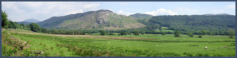 |
A view of the Ulpha Fells from near Muncaster Head |
Top
Sunday 1 June
6->7 7.07km 980m ascent 3 hrs, 24 mins
7 Sca Fell NY 206 065
7->8 3.12km 17m ascent 49 mins
8 Maiden Castle NY 183 056
8->9 1.71km 312m ascent 57 mins
9 Illgill Head NY 168 049
9->10 3.22km 75m ascent 56 mins
10 Path junction NY 145 027
10->11 1.18km 1m ascent 18 mins
11 Another Path junction NY 143 037
11->12 1.06km 21m ascent 18 mins
12 Wasdale YHA NY 144 044 0870 770 6082
One room with 4 beds, Sue E in a B&B. Hostel meal, breakfast and packed lunch.
Totals for Day 2: 17km, 1406m ascent, 6.7 hours walking (actual 8 hours 30 mins including 2 hours stops).
Alternatively if Sca Fell is missed out – 14km, 708 metres ascent (Notchy did this).
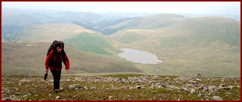 |
Sue climbs purposefully up Sca Fell, with Burnmoor Tarn and Illgill Head behind |
Top
Monday 2 June
12->13 2.26km 46m ascent 38 mins
13 Path junction NY 157 061
13->14 5.35km 644m ascent 2 hrs, 25 mins
14 Col at 700 metres NY 148 108
14->15 0.41km 92m ascent 15 mins
15 Haycock NY 144 107
15->14 0.41km 0m ascent 6 mins
14 Col at 700 metres NY 148 108
14->16 1.11km 136m ascent 30 mins
16 Little Scoat Fell NY 157 114
16->17 1.21km 97m ascent 28 mins
17 Wind Gap NY 168 118
17->18 0.43km 103m ascent 17 mins
18 Pillar NY 171 121
18->19 2.28km 29m ascent 37 mins
19 Path junction NY 191 114
19->20 1.42km 20m ascent 23 mins
20 Black Sail Hut NY 194 123 07711 108450
4 beds in dormitories, Sue E has booked separately. Hostel meal, breakfast and packed lunch.
Totals for Day 3: 15km, 1167m ascent, 5.6 hrs walking (actual 8 hrs 5 mins including 1 hr 50 mins stops).
Alternatively just go over Black Sail Pass – 14 km, 674 metres ascent, or (much longer) go over all the tops.
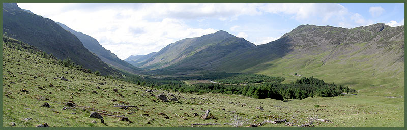 |
The view down Ennerdale, with Haystacks above Black Sail Hut, and High Crag beyond, with remains from the notorious forest (now partly felled) in the foreground |
Top
Tuesday 3 June
20->21 1.47km 247m ascent 47 mins
21 Path junction NY 205 124
21->22 1.72km 116m ascent 37 mins
22 Hay Stacks NY 193 131
22->23 0.48km 5m ascent 8 mins
23 Path junction NY 189 133
23->24 1.24km 327m ascent 51 mins
24 High Crag NY 180 140
24->25 1.59km 166m ascent 40 mins
25 High Stile NY 167 147
25->26 1.19km 55m ascent 23 mins
26 Red Pike NY 160 154
26->27 2.21km 0m ascent 33 mins
27 Scale Force NY 150 171
27->28 1.46km 13m ascent 23 mins
28 Path junction NY 163 169
28->29 2.21km 44m ascent 28 mins
29 The Fish Hotel NY 174 169
29->30 1.84km 55m ascent 33 mins
30 Dalegarth NY 186 159 017687 70233
1 double and 3 single rooms. Eat in Fish Hotel and get lunch from Dalegarth.
Totals for Day 4: 15km, 1028m ascent, 5.4 hours walking (actual 8 hrs 40 mins including 2 hrs 20 mins stops). Plus the 4km return trip to the Fish Hotel for a meal.
The shortest route is only 6 km, the one described is the longest.
There are many possible short cuts.
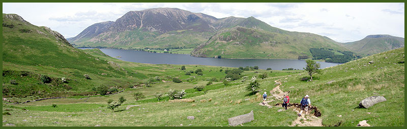 |
Descending from Scale Force towards Buttermere, with Crummock Water and Grasmoor in view |
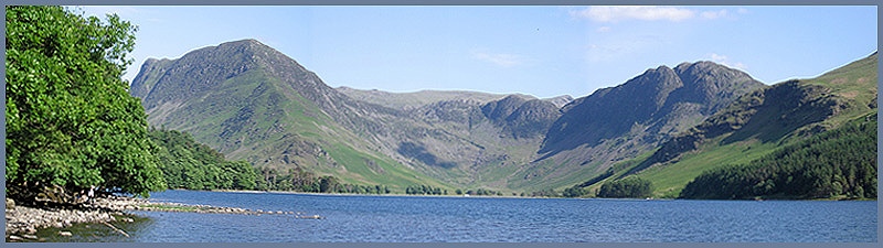 |
Buttermere with Fleetwith Pike and Haystacks, from the lakeside path |
Top
Wednesday 4 June
30->29 1.84km 42m ascent 32 mins
29 The Fish Hotel NY 174 169
29->31 0.26km 24m ascent 7 mins
31 Camping Barn at Buttermere NY 173 171
31->32 0.84km 183m ascent 31 mins
32 Path junction NY 179 177
32->33 1.91km 435m ascent 1 hr, 12 mins
33 Path Junction NY 183 195
33->34 1.86km 166m ascent 45 mins
34 Grasmoor NY 174 203
34->35 2.91km 181m ascent 1 hr, 2 mins
35 Hopegill Head NY 185 221
35->36 3.49km 32m ascent 56 mins
36 Path meets road NY 175 252
36->37 1.03km 8m ascent 16 mins
37 High Swindale NY 169 245
37->38 1.61km 1m ascent 24 mins
38 High Lorton NY 161 255
38->39 0.98km 1m ascent 15 mins
39 Path Junction NY 155 260
39->40 0.69km 0m ascent 10 mins
40 Path Junction NY 152 263
40->41 3.38km 61m ascent 57 mins
41 Byersteads NY 147 288 01900 822223
2 double and 1 twin room. Eat across the road at Hundith Hill.
Totals for Day 5: 21km, 1134m ascent, 7.1 hours walking (actual 7 hrs 40 mins including 1 hr 45 mins stops). Plus the 1.5km return trip to the Hundith HillHotel for a meal.
Alternatively avoid Grasmoor – 19 km, 600 metres ascent.
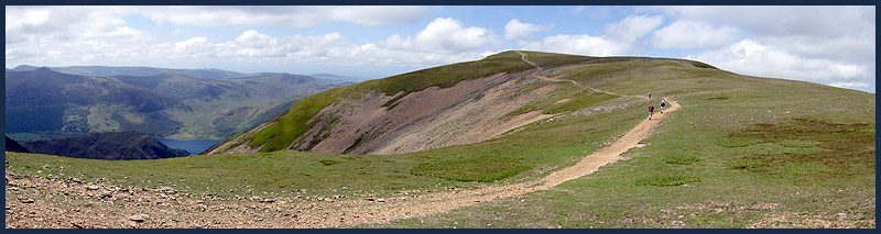 |
The last lap to the summit of Grasmoor, with Crummock Water behind |
Top
Thursday 5 June
41->43 5.32km 55m ascent 1 hr, 25 mins
43 Cockermouth centre NY 122 307
Buy lunch for the next two days in Cockermouth.
43->44 7.70km 175m ascent 2 hrs, 13 mins
44 Path junction NY 166 336
44->45 4.21km 49m ascent 1 hr, 8 mins
45 Junction NY 199 321
45->46 1.62km 25m ascent 27 mins
46 Link House NY 197 312 017687 76291
2 double and 1 twin room. Eat at the Wheatsheaf Inn, Embleton (a half hour walk, but we got a lift from Keith),
or more luxuriously at the famous Pheasant Inn (a 10 minute walk).
Totals for Day 6: 19km, 304m ascent, 5.2 hours walking (actual 7 hrs including 2 hr 10 mins stops). Plus the 2.5km walk back from the Wheatsheaf Inn.
Alternatively take the southern version of the Allerdale Ramble, and save 30 minutes.
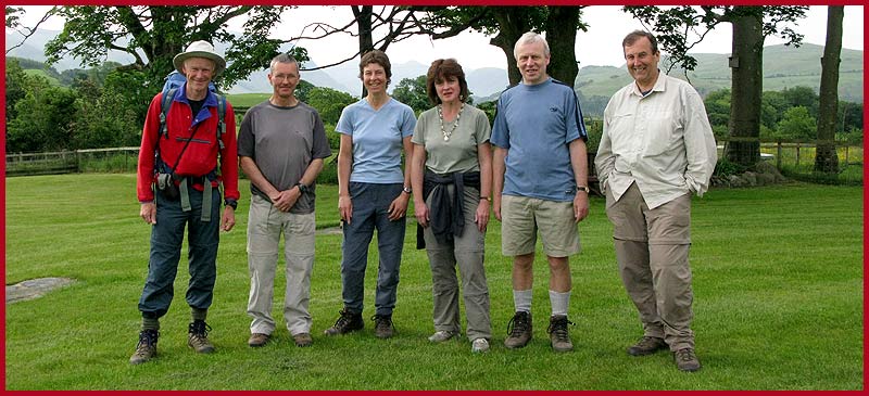 |
The team assembled outside The Old Homestead |
Top
Friday 6 June
46->45 1.62km 17m ascent 26 mins
45 Junction NY 199 321
45->47 1.09km 17m ascent 18 mins
47 Armathwaite Hall entrance NY 208 323
47->48 2.58km 51m ascent 44 mins
48 Bassenthwaite NY 231 322
48->49 3.60km 186m ascent 1 hr, 13 mins
49 Orthwaite NY 252 341
49->50 2.39km 62m ascent 42 mins
You may find one of these on this section
50 Longlands NY 266 359
50->51 2.53km 105m ascent 49 mins
51 Green Head NY 286 370
51->52 2.07km 53m ascent 36 mins
52 Fell Side NY 304 375
52->53 2.58km 46m ascent 43 mins
53 Path junction NY 323 378
53->54 3.32km 14m ascent 51 mins
54 The Oddfellows Arms Caldbeck NY 325 397 016974 78227
1 double and 1 family room. Eat in the pub.
Totals for Day 7: 22km, 551m ascent, 6.4 hours walking (actual 7 hrs including 1 hr 40 mins stops).
We should really have gone over Skiddaw…31 km, 1447 metres ascent!
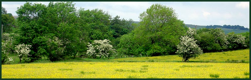 |
A buttercup meadow near Green Head |
Top
Saturday 7 June
54->55 4.92km 78m ascent 1 hr, 22 mins
55 Sebergham NY 356 418
55->56 9.19km 76m ascent 2 hrs, 25 mins
56 Bridge End NY 369 487
56->57 2.26km 10m ascent 35 mins
57 Dalston Station NY 365 505
Train back to Ravenglass - £12 for a single ticket. (Sue and David adjourn independently to Langdale.)
Trains leave Dalston at 12,49, 14.36 and 15.53, arriving at Ravenglass at 14.24, 16.06 and 17.21 respectively.
Totals for Day 8: 16km, 164m ascent, 4.4 hours walking (actual 5 hrs 15 mins including 1 hr 30 mins stops).
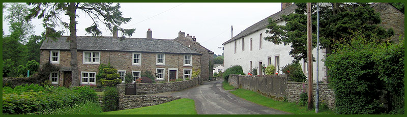 |
Caldbeck village |
Total trip 145km 6,227m ascent 46 hrs
Essentials
All participants are recommended to be members of
the Youth Hostels Association or an
affiliated body. YHA membership costs £15.95 and can be obtained by completing
the on-line
form. Alternatively you can pay a supplement of £3 each night.
Top
Kit List
This list
may include items not everyone will need - it's intended as a checklist and
whilst not exhaustive does cover both essentials and luxuries! Obviously weight should
be kept to a minimum and advice on the
most
effective kit can be provided.
Rucksack
35 to 50 litres plus waterproof liner
Silk liner for use in youth hostels if you dont like their cotton liners
Cagoule / Overtrousers / Fleece / Sunhat
Gloves / Balaclava or woolly hat
Torch (small)
Walking-poles (optional)
Walking Socks (2 pairs) / Underwear / Wicking shirts (2) / Handkerchiefs
Water Bottle(s) / mug
Food for snacks / special teas / other special requirements / Lunchbox
Trainers or sandals for evenings/ Boots or all terrain shoes
Camera / Binoculars / Film / spare batteries for torch and camera / Tripod
Pen / Paper / Book to read / Bog roll
Clock / watch
Glasses / contact lenses (for the poor sighted )/ Glasses case / Cloth Cleaner
Sunglasses / Suntan cream / lip salve
Boot Wax
Toothbrush / Toothpaste / Dental floss / Shampoo / Razor (if prone to hairiness)
Comb / Travel Towel
Lux Flakes or similar to dunk sweaty underwear
Cash / Tickets
Timetables / other papers / Addresses for postcards / This List / Keys
Favourite tapes / CDs / personal stereo)
Additional
items for leader:
Maps
Emergency shelter
Stove / Pan / Mugs / JCloth / Knife / Spoon / butty bags
Matches / needle / thread / tape
Elastoplast/ Aspirin / Diocalm / Savlon / Wipes
Compass / Whistle / First aid kit
Can Opener / penknife