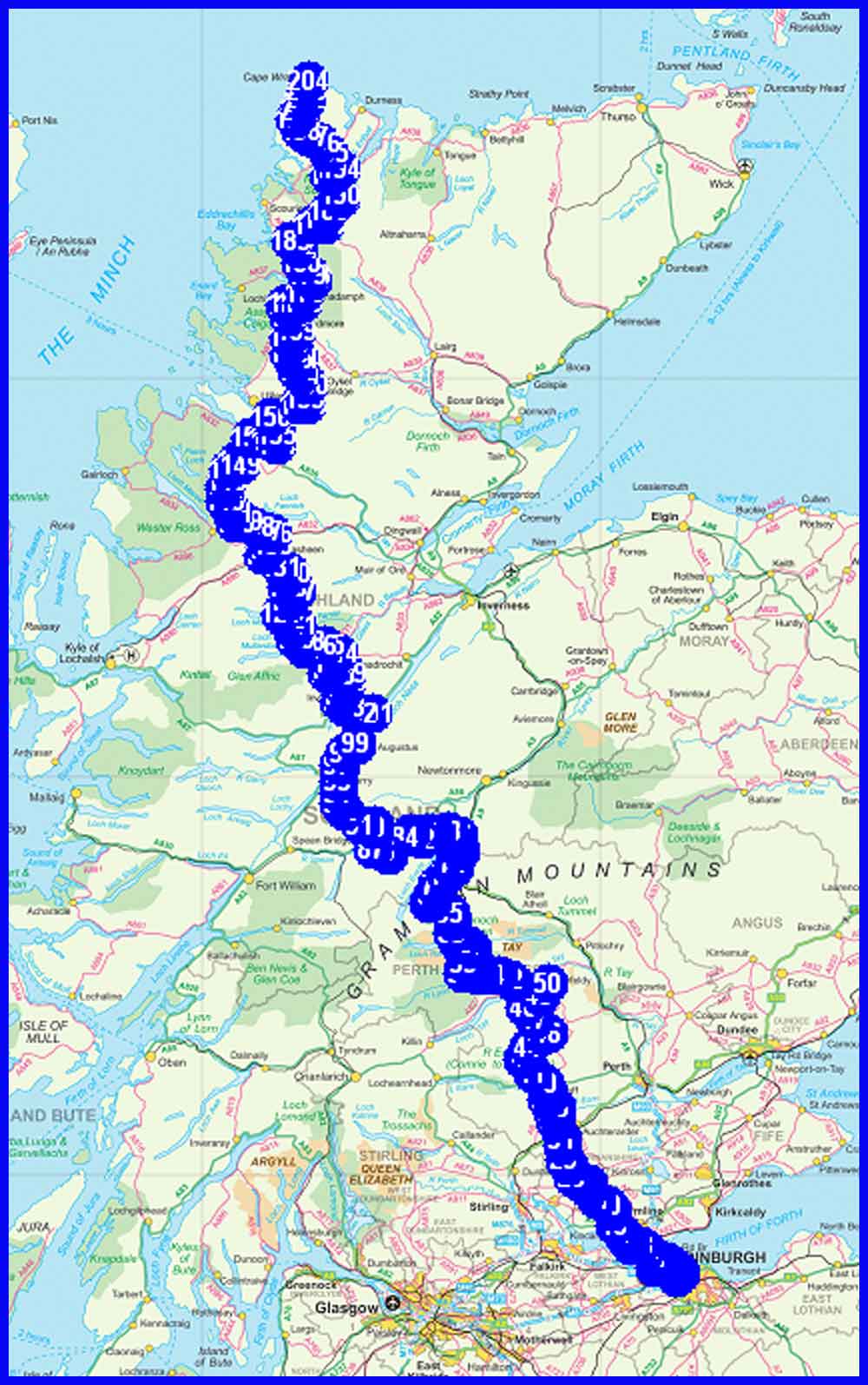
Planned Route and Estimated Statistics
(M) = Munro
(C) = Corbett
Day 1 - Wednesday 14 April
1 Cramond
2 Cramond Bridge
3 Eagle Rock
4 Snab Point
5 Dalmeny House
6 Barnbougle Castle
7 Hound Point
8 Long Gate
9 South Queensferry Pier
10 South Queensferry
11 North Queensferry
12 Rosyth
13 Brucehaven
14 Charlestown (Hotel)
Plan
24 km
452 metres ascent
8.25 hours
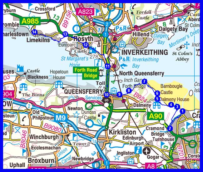
Actual
Apparently, as planned
Prologue: Received from Markus 2300, 13 April.
Have successfully finished the first section of the Caledonian Trail. From Munich to Edinburgh. Wolfi says your page is looking cool.
Day 1 Report, received from Markus 1930, 14 April.
Hi folks! This is my first report from the honeymoon trail. Yes from the Honeymoon and not Caledonian Trail. Thanks to the Elgin Hotel I'm sleeping tonight in the honeymoon suite. Feeling a bit like the King of Siam without a harem.
Back to the trail: Cramond is an atmospheric start point. Highlights: River Almond walk, Forth coast, the wobbly traverse of the Forth Road Bridge, the pittoresque (sic) harbour of Charlestown. Mixed weather with sun in the afternoon.
Feeling great.
A Thirsty Desperado
Return to top
Day 2 - Thursday 15 April
1 Charlestown
2 A985 road
3 Mire End
4 Cairneyhill
5 Oakley
6 Saline
7 Shieldbank
8 Solsgirth
9 Dollar (a town)
10 Castle Campbell
11 Bank Hill
12 King's Seat Hill
13 Backhills
14 Upper Glendevon Reservoir (wild camp around NN 903 044 - 350 metres)
Plan
33 km
1092 metres ascent
12.5 hours
Actual
Day 2 Interim Report, received from Markus at 1530
Have now arrived at Dollar. I'm expecting no dollars at Dollar. I'm enjoying the freedom of backpacking, the singing of birds and the freshness of spring. It feels magical following spring to the far north of Scotland. Mostly roadwalking so far. T-shirt weather. Now it's into the hills. Will be taking seat onto King's Seat. No dram tonight but a wild camp beneath the stars.
Return to top
Day 3 - Friday 16 April
1 Wild camp
2 Glen Bee
3 Blackford
4 Kirkton
5 Middleton
6 Bridge on A822 road
7 Muthill
8 Farm lane
9 Railway track
10 Rejoin A822 road
11 Crieff (B&B or campsite)
Plan
26 km
355 metres ascent
8.8 hours
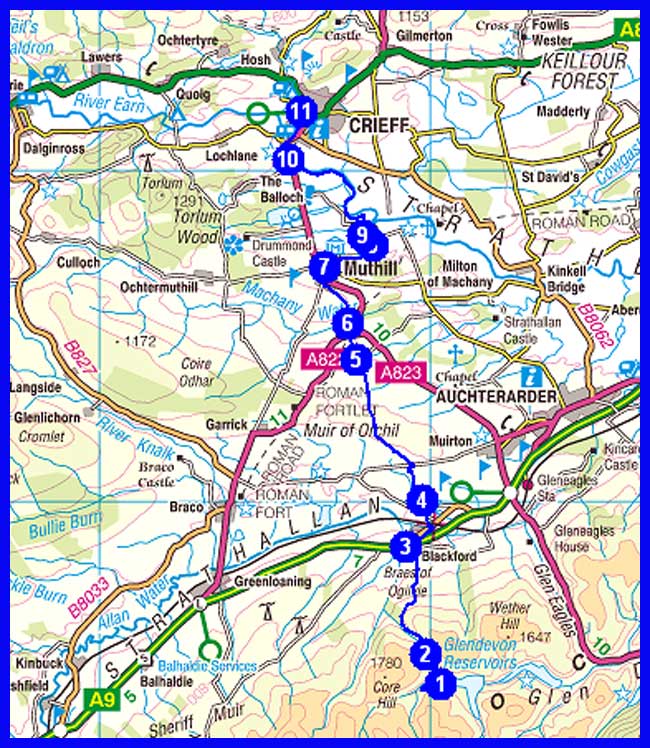
Actual
Day 3 First Report, received from Markus (via Martin) at 1230
Thanks for the fine forecast dear Saint Martin in the Fields*
Does volcanic ash in the air mean that temperatures will plummet down to freezing level?
On my way into the wilds, I'm now enjoying a rest in a shopping mall at Blackford.
Last night was a bit miserable. Glen devon is a bumpy place. No running water nearby. No dinner. No breakie. Just woolies for company. The right place for aard men.
Mac
* Markus refers here to Martin's wake up call to him:
"Good morning sir
Today's forecast:
Precipitation:
Rain: 0
Snow: 0
Volcanic Ash: 10 cm?
Planes can't fly through it. You won't see any today. Should get nice sunrise and sunset though."
Day 3 - second instalment
I'm happy to report skies are still blue over Scotland and my skin still looks fresh. Maybe a bit smelly .. Another happy backpacking day. Mostly on farmland tracks with some route finding problems after Whitehills. Wonderful going before Muthills. A pretty village. Have now arrived at Crieff on the doorsteps of the highlands. Where eagles soar and ridges call. For those who wonder how it is like to camp out in a highland night I recommend Jim Malcolm's version of 'Now Westlin Winds' from his album 'Acquaintance'. Wonderful piece of music. Download from amazon.de or co.uk. Looks cool for tomorrow. The uk may be grounded but I'll still be on the track. Wish you all a wonderful weekend!
Mac
Return to top
Day 4 - Saturday 17 April
1 Crieff
2 Dalvreck
3 Greenend
4 Loch Turret Dam
5 Track junction
6 Auchnafree Hill (C)
7 Larichfraskhan
6 Lochan a' Mhuilinn (wild camp around NN 847 360 - 400 metres)
Plan
24 km
1176 metres ascent
10.1 hours
(1 Corbett)
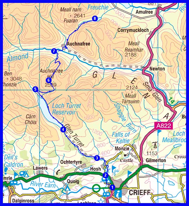
Actual
Day 4 Report - Morning
My first night under a highland moon. The Highlands. Murmuring ancient tales and echoing a dramatic past. Sorry for this Walter Scottish style word rap. I like it. Had some good banter at Crieff which comes from Gaelic 'craobh' meaning 'among trees'. Bought a smallish bottle of Glen Turret single malt. For feeling comfy. Now its to Loch Turret and over the hills. A wee bit cool today.
Day 4 Report, continued
The magic of the Highlands is hard to resist. After a short visit to the Glen Turret distillery, the oldest in Scotland, I headed to Loch Turret and on landrover tracks to Auchnafree Hill. Dark clouds were gathering in the west when I dropped down to Glen Almond. This hill seems to be a nirvana for mountain hares. Over a small bealach, gaelic for 'pass', it was to Glen Oich and to a wild damp camp for the night.
Return to top
Day 5 - Sunday 18 April
1 Wild camp
2 Croftmill
3 By Garrow
4 Junction by small lochan
5 Urlar
6 Aberfeldy (Camp site)
Plan
22 km
410 metres ascent
7.8 hours
Plan to meet Martin B at the camp site and walk 'together' (see above) for six days to Fort Augustus
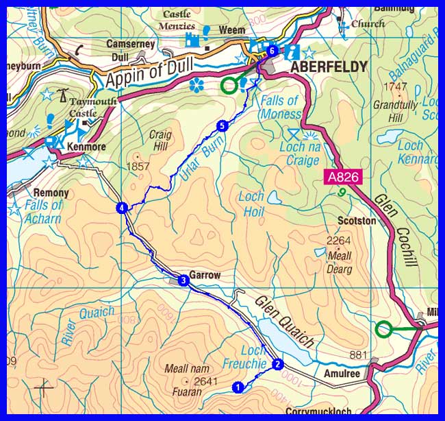
Actual
Day 5 Report
Next morning I was greeted by snow showers and cool winds. And the calls of Barnacle Geese. Sounding much better than Lady Gaga. Today it was on tarmac and LRTs to Aberfeldy, for a meeting with Martin and Ian as planned.
Return to top
Day 6 - Monday 19 April
1 Aberfeldy
2 Keltneyburn
3 Garth Castle
4 Path junction
5 Land Rover Track
6 Meall Liath
7 Carn Mairg (M)
8 Meall a' Bharr
9 Meall Garbh (M)
10 Bothy (wild camp around NN 651 540 - 550 metres)
Plan
28 km
1365 metres ascent
11.5 hours
(2 Munros)
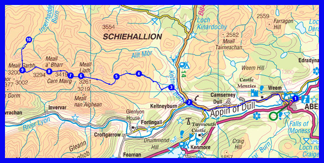
Actual
Day 6 Report
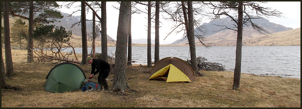
April in the highlands can bring 4 seasons a day. When we got up this morning winter had returned to the Braes of Aberfeldy. After a quick cuppa martin and I waved goodbye to Ian and walked along the B846 to Keltney. A nice alternative route follows the River Tay. After Keltney our route left the road heading into peaty hills. Many false tops lead us onto the summit of Carn Mairg (1042m). A wind-swept, barren place. None to linger. Far horizons everywhere. Schiehallion, the fairy hills of the Caledonians, thrones boldly to the north. Down to Glen Sassunn for a wild night inside our little tents which are our cocoons against the raging elements outside. It's snowing again. Hoping our sleeping bags'll give some comfort.
It's a wild world out there.
Goodnight.
Markus
Martin's Blog Report
Return to top
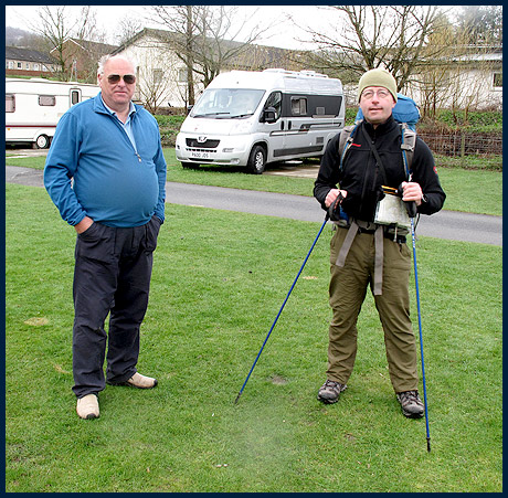 |
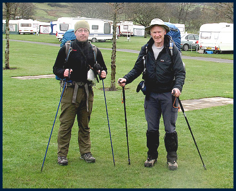
Trail Daddy, Markus and Martin at Aberfeldy |
Ascending Meall Liath
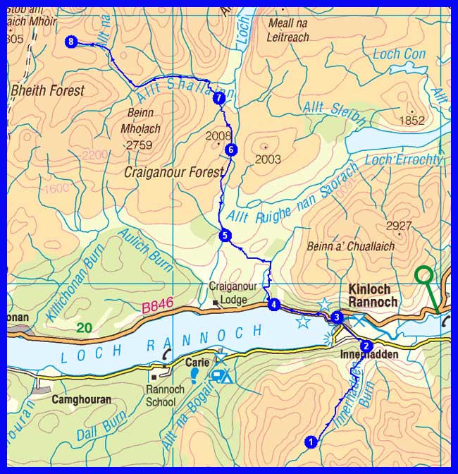
Day 7 - Tuesday 20 April
1 Wild camp
2 Innerhadden
3 Kinloch Rannoch
4 By Annat
5 Allt a' Chreagain Odhair
6 Col by Gualann Sheileach
7 Duinish
8 Loch Monaidh (wild camp around NN 562 690 - 700 metres)
Plan
26 km
700 metres ascent
9.3 hours
Actual
Day 7 Report
Having pitched our tents in a hidden corner of the west Drumochter hills I'm trying to write down some lines which sum up another day on the trail. A day with some magic moments. Enjoyed a late breakie at Kinloch Rannoch. Loch Rannoch was glorious in the sunshine. The distant Glen Etive munros to the west were glistening in pristine white. The Caledonian Trail casts its spell upon me. On landrover tracks we carry on to Loch Garry. Accompanied by occasional snow showers. Across a landscape of Tolkienesque grandeur. At Duinish bothy we're greeted by bunnies with scientifically perfect built-up bodies. Our intended high camp at Loch Monaidh seemed too cold for this night so we pitched our tents further down along the Allt Shallainn. A good choice.
Martin's Blog Report
Return to top
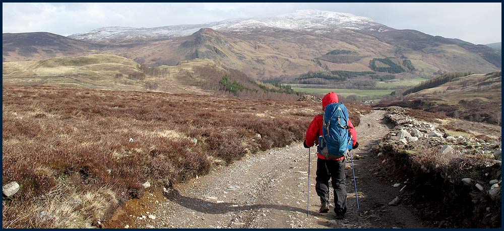
Descending towards Kinloch Rannoch
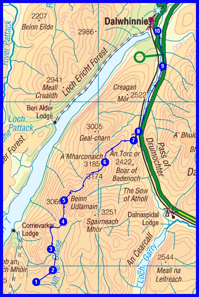
Day 8 - Wednesday 21 April
1 Loch Monaidh
2 Glas Mheall a' Chumhainn
3 Cul an Aonaich Oidhir
4 Carn 'lc Loumhaidh
5 Beinn Udlamain (M)
6 A' Mharconaich (M)
7 Land Rover Track
8 Join cycle track
9 By Wade Bridge
10 Dalwhinnie (for bus or lift to Newtonmore - Eagle View Guest House)
Plan
20 km
641 metres ascent
8.0 hours
(2 Munros)
Actual
Day 8 Report
A walk on the wild side today. It felt hard in the morning to get out from the warmth of the sleeping bag. Two munros were waiting. Broad ridges separated by boggy cols. Made fast progress. In a subarctic landscape. With reminiscences of Spitsbergen. But grouse and hares instead of reindeers and ice bears. We didn't look very civilized when we arrived at Newtonmore. Battled and knackered. But with lingering memories! Two men on the trail.
MAC
Martin's Blog Report
Return to top
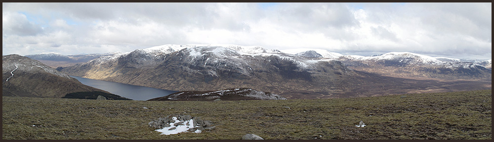
Ben Alder from the ascent of Beinn Udlamain
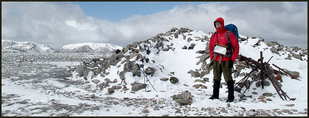
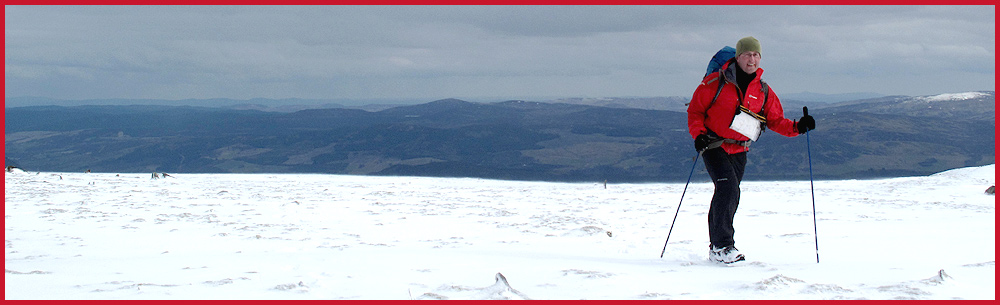
On the Munro summit of Beinn Udlamain - 1011 metres
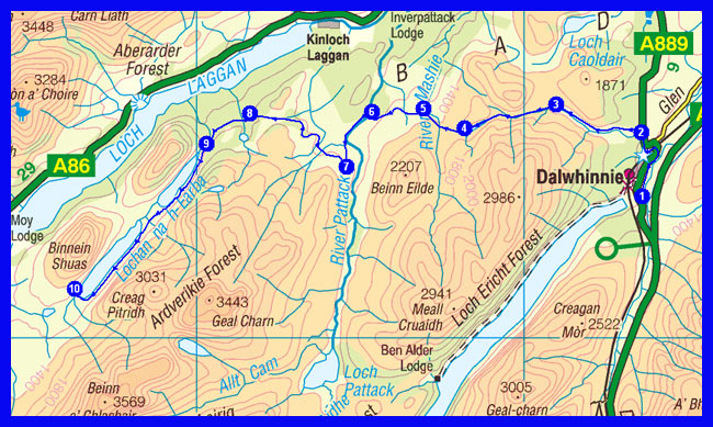
Day 9 - Thursday 22 April
1 Dalwhinnie (return by bus or lift)
2 A889 road
3 Turn west south west
4 By Lochan na Doire-uaine
5 Start of track
6 Join Land Rover Track
7 Path junction
8 Track junction
9 Head of loch
10 Loch na h-Earba (wild camp to the south of the loch around NN 463 814 - 360 metres)
Plan
27 km
471 metres ascent
9.1 hours
Actual
Day 9 Report
After 4 cool nights in the tent the Eagle View Guest House at Newtonmore provided a more luxurious lifestyle for 2 brave lads on the trail. Scottish hospitality at its best. Breakie was a belly buster. Started at 10 am from Dalwhinnie bus stop. Along the Allt an t-Sluic threading a way through a narrow cleft past gnarly birch trees and over moss-covered rocks we headed to Lochan na Doire. Beyond breathtaking highland scenery, open spaces were waiting.. A rather cool, windy day. On ltr to Lochan na h-Earba. The calls of curlews filled the air. Found an atmospheric camp spot among a stand of Caledonian pines. There's so much beauty around. This trail will test your stamina and your gear. But special moments are the reward!
MAC
Martin's Blog Report
Return to top
Our wild camp at Knipe Copse, beside Lachan na h-Earba
Day 10 - Friday 23 April
1 Wild camp at 360 metres
2 Track junction
3 Moy Burn
4 Creag Meagaidh (M)
5 The Window
6 Lochan Uaine
7 Path to Burn of Agie
8 Annat
9 Gleann Eachach (Martin will probably stop here)
10 Carn na Larach
11 Glenbuck (wild camp around NN 334 995 - 290 metres)
Plan
34 km
1589 metres ascent
14.5 hours
(1 Munro)
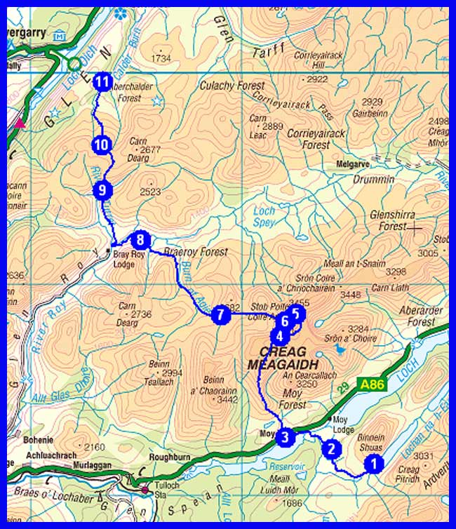
Actual
Day 10 Report
A day of unrelenting rain. Climbing Creag Meagaidh in this horrendous weather had to be abandoned. We're no loons. Instead it was past Beinn Teallach down to the Burn of Agie. Even in this dark gloom the landscape looked majestic. Two risky river crossings challenged our skills. Martin's waterproof socks used as mitts saved the day. Thanks martin! Otherwise would have got into serious troubles. Pitched camp near Annat. Was a wet night.
MAC
Martin's Blog Report
Return to top
Early morning view of Binnean Shuas from Knipe Copse
Day 11 - Saturday 24 April
1 Wild camp at Glenbuck
2 Aberchalder
3 Bridge of Oich
4 Kytra Loch
5 Road junction
6 Fort Augustus (Cumberlands Camp Site)
Plan
14 km
77 metres ascent
4.4 hours
Martin leaves here. Exhausted.
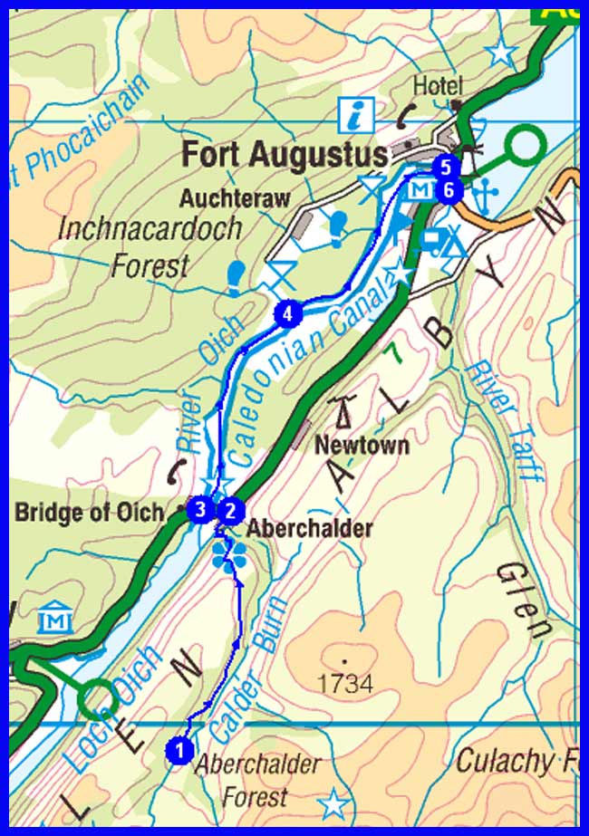
Actual
Day 11 Report (Saturday):
In the morning almost everything inside the laser tent felt damp and clammy. Condensation problems. At 9 am we set off on the track. Glen Roy is full of glacial relics. A brutally steep climb took us onto the top of Meall na Teanga which forms part of a high moorland plateau. Groups of red deer crossed our path. Aided by gps Martin navigated a course across this trackless terrain. The grand hilldom of the NW Highlands was rising to the west. Down with a bumslide to Glen Buck. Along the Caledonian Canal to Fort Augustus where I was invited to a meal by Martin. Thanks for your company Martin . You're a true friend!
MAC
Martin's Blog Report
Return to top
On Carn na Larach
Day 12 - Sunday 25 April
1 Fort Augustus
2 Road junction
3 Invermoriston
4 Bhlaraidh
5 Bhlaraidh Reservoir
6 Loch Liath
7 Loch ma Stac
8 By Loch ma Stac
9 North of lochan
10 Wild camp (around NH 353 248 - 410 metres)
Plan
29 km
960 metres ascent
10.9 hours
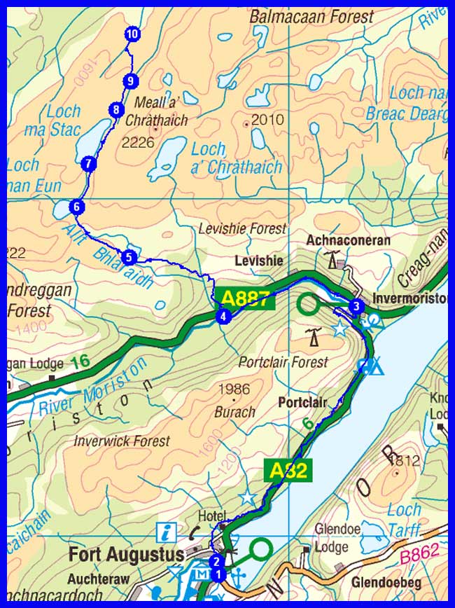
Actual
Day 12 Report (Sunday):
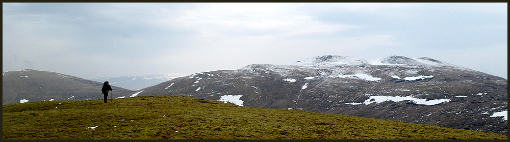
On my own again. Goodbye Martin. It was fun. Between Fort Augustus and Invermoriston I followed the Great Glen Way. A walk among trees and on bulldozed tracks. The dark, peaty waters of Loch Ness cast deep shadows. The scent of trees fills the air. Along the A887 as far as Bhlaraidh. Where I enjoyed a good chat with Leonard Grant. A likeable character who offered me a lift on his quad bike. A former deer stalker who has many friends in Austria. Into wild country again. A LRT climbs steadily to Loch ma Stac. A derelict building sits on the far side. Haunting place. Found a good spot for the tent by the River Enrick.
MAC
Return to top
Day 13 - Monday 26 April
1 Beautiful wild camp
2 By Abhainn na R Duibhe
3 Loch na Beinne Moire
4 Guisachan
5 Tomich
6 Road junction
7 Cannich
8 Track junction
9 Another track junction
10 Leave minor road
11 Liatrie Burn
12 Druim Dubh un Fhuarain
13 Wild camp (around NH 219 375 - 250 metres)
Plan
33 km
1052 metres ascent
12.7 hours
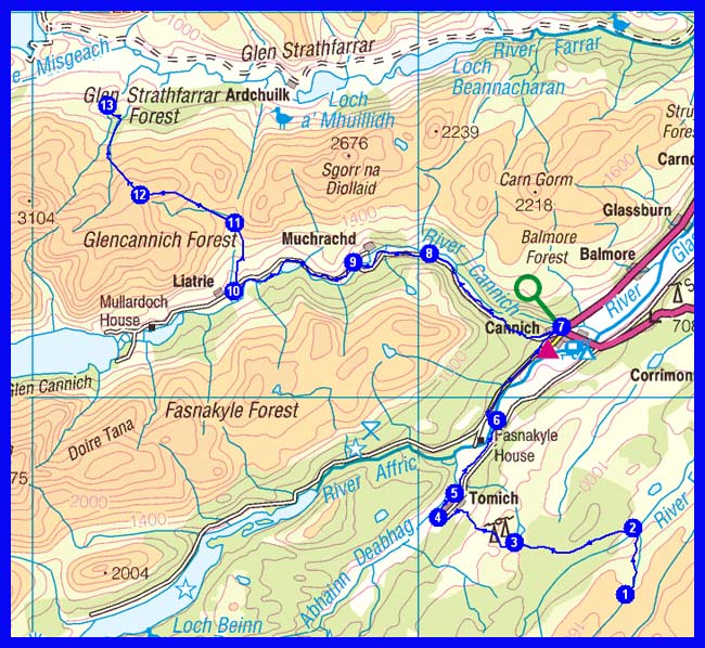
Actual
Day 13 Report (Monday):
The rich man's out in Highland skies. In the morning sun the tent was a warm and comfy place. Could have lingered for hours. But a hard day was waiting. Brilliant weather for a walk. The wild hills of Glen Affric looked pretty with their white topping. Late breakie at the Tomich Hotel. Charming countrystyle. On tarmac to Cannich and Glen Cannich. Had a strange encounter there. A few seconds after a pee stop a Google street view car was passing. The upper reaches of Glen Cannich are a wild place. Stocked with Caledonian pines and backed by awesome hills. The ascent of Druim Dubh un Fhuarain was straightforward. Found a magic grassy spot for my laser. Among pines and with views to the Strathfarrar Munros.
MAC
Day 14 - Tuesday 27 April
1 Idyllic wild camp
2 The Bridge at Inchvuilt
3 Monar Lodge
4 By Loch Monar
5 Junction by Coire Dhomhain
6 Above River Orrin
7 Loch na Caoidhe
8 Torran Ceann Liath
9 Drochaid Coire Mhadaidh
10 Corriefeol
11 Scardroy Lodge
12 Edge of woods
13 A890 road junction by Inver
14 Achnasheen (Hotel)
Plan
37 km
1303 metres ascent
14.5 hours
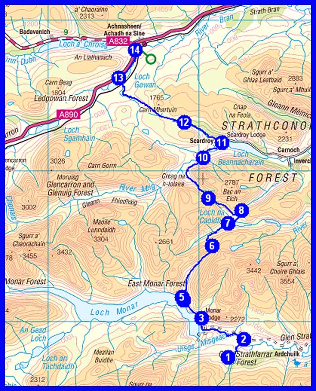
Actual
Day 14 Report (Tuesday):
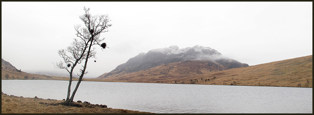
Got up at 5.30 and left before 7. A hard walk against time today. Not sure if I'd make it as far as Achnasheen. Passed a feral goat before the Monar dam. Loch Monar. A loch with a breathtaking panorama! A vast expanse of water surrounded by a crown of cloud covered hills. Over two bealachs to Scardroy Lodge. The paths always petered out on the highest points. Steep descent down to the Orrin River. Another gem of the day. Loch na Caoidhe. Must come back one day. Hard slog from Scardroy to Loch Gowan. In drizzle. In good weather this must be a first-class panorama walk. Ledgowan Lodge Hotel at last. A place crammed with nostalgia. And Victorian touch. Felt a bit underdressed. Very nice owners.
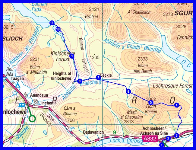
Day 15 - Wednesday 28 April
1 Achnasheen Hotel
2 Achnasheen Station
3 Track junction
4 Sail an Tuim Bhain
5 Fionn Bheinn (M)
6 By Allt a' Chlaiginn
7 Leckie
8 Bridge
9 Gleann na Muice - end of track
10 By Loch an Sgeireach
11 By Lochan Fada (wild camp around NH 050 699 - 310 metres)
Plan
24 km
1188 metres ascent
10.2 hours
(1 Munro)
Actual
Day 15 Report (Wednesday):
I was the only guest last evening in the bar of the Ledgowan. Enjoyed a good banter with the barman who's also the hotel owner. Had a late start as the weather didn't look very promising. Again no tops. My FWA: along the road to Kinlochewe. 10 miles. Was almost blown off by a gust on the first mile. Some nice views along the road. My feet were still aching from yesterday's marathon. Lunch stop in the Kinlochewe Hotel. Nice place. Later via the Heights of Kinlochewe to Lochan Fada. Gleann na Muice is well stocked with young native trees. Pine, birch, rowan. This glen will become a gem in the future. Higher up big wee mountains with steep flanks dominated the horizon. The Letterewe Forest. A wild wonderland. Almost bare of good camp spots.
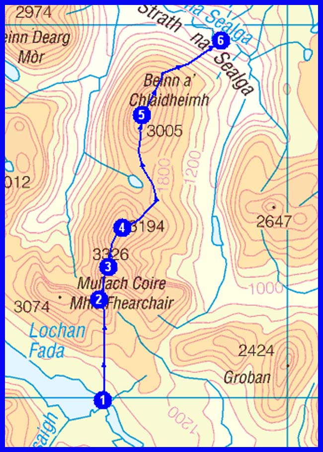
Day 16 - Thursday 29 April
1 Wild camp by Lochan Fada
2 Meall Garbh
3 Mullach Coire Mhic Fhearchair (M)
4 Sgurr Ban (M)
5 Beinn a' Chlaidheimh (M)
6 Achneigie (wild camp around NH 082 795 - 120 metres)
Plan
12 km
1295 metres ascent
7.4 hours
(3 Munros)
Actual
Day 16 Report (Thursday):
In the morning I was surprised to see another tent pitched nearby. Had a late start as it wasn't clear if the weather would permit the planned ridge walk. Set off at 11 am. A faint track led towards Meall Garbh. Wandering sunny patches on show. Fantastic views. Even out to the blue waters of the Minch. Mullach Coire Mhic Fhearchair followed. A fine perch. Above, a pair of eagles showing grace and pride. Very steep rocky descent down to the next col. Sleet and gales on Sgurr Ban. Decided to leave the next top for another day. Dropping down from Sgurr Ban was a horrible affair over loose stones and slippery boggy ground. With bare feet across the Abhainn Loch an Nid. The water felt icy cold. Just a few kilometres today. Hard work though.
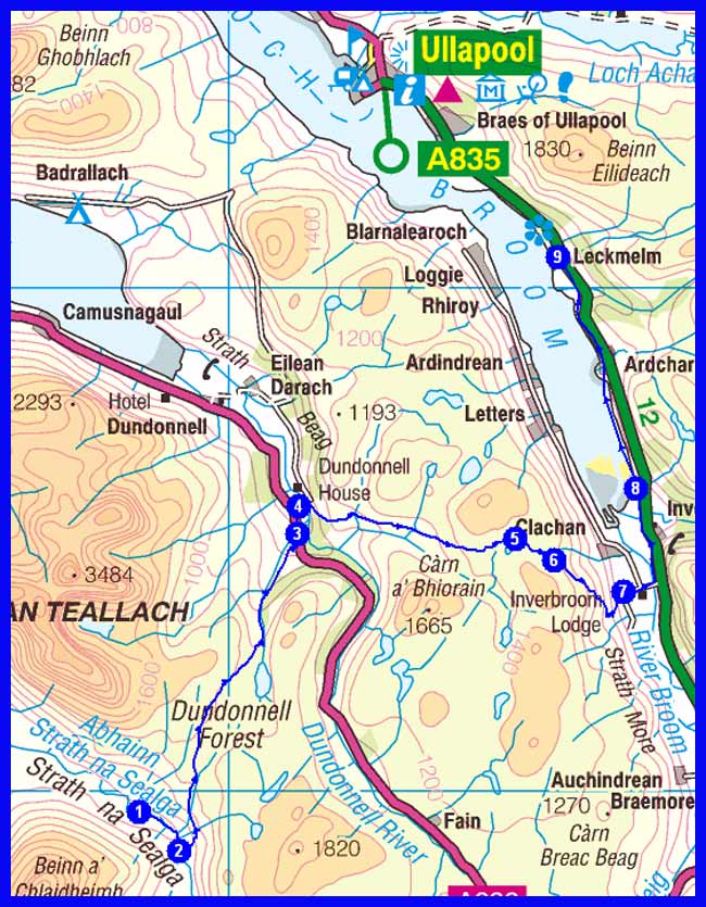
Day 17 - Friday 30 April
1 Wild camp at Achneigie
2 Path junction
3 Corrie Hallie
4 Bridge over Dundonnell River
5 Loch an Tiompain
6 By small lochan
7 Croftown
8 Inverlael
9 Leckmelm (for Ullapool, by bus or lift)
Plan
25 km
874 metres ascent
9.9 hours
Actual
Day 17 Report (Friday):
Felt privileged this morning. Watched great landscape painting by Van Scot. On display for a minute near Achneigie Gallery Hall. Loch na Sealga shimmering in the distance, dancing cloud veils around Beinn Dearg Mor. Framed by a rainbow. Again a damp tent to pack. On LRT down to Corrie Hallie. Finding the track leading over the hills to Strath More proved a bit tricky and caused havoc among a flock of sheep. There's a waterfall along the track with fine pools. Sunny spells and hail showers. It's a steep drop down to Loch Broom. Heavy traffic along the road to Ullapool. I can see the sea.
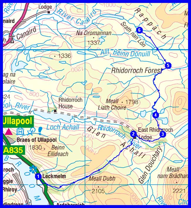
Day 18 - Saturday 1 May
1 Leckmelm (via Ullapool)
2 By East Rhidorroch Lodge
3 Junction before Loch an Daimh
4 By Clar Lochan
5 Junction - Allt Beinn Donuill
6 North of Clar Lochan (wild camp around NC 240 014 - 200 metres)
Plan
22 km
757 metres ascent
8.4 hours
Actual
Day 18 Report (Saturday):
The first of May started with cool temperatures and grey skies. A taxi dropped me off at Leckmelm. En route to Glen Achall I had a fascinating encounter. With a juvenile eagle. Soaring 20 metres above me. The guardian of the land saying hello. Could see its eyes. The track goes straight across the grounds of East Rhidorroch Lodge. Near Knockdamph I left the LRT and entered the Rhiddoroch Forest. A wild tract of land. Great views. The castellated peaks of Assynt standing prominently to the west. No problems with fording the Rappach Water. Opted for a lazy evening and pitched camp at NC 265 986. [Near Point 5 on the planned route.]
Return to top
Day 19 - Sunday 2 May
1 Wild camp north of Clar Lochan
2 By Allt Rappach
3 Meallan Odhar
4 Meall a' Bhuirich
5 A' Chioch
6 Meall Coire an Lochain
7 Abhainn a' Chnocain
8 Knockan
9 Path junction
10 East end of Loch Fada
11 Meall Diamhain
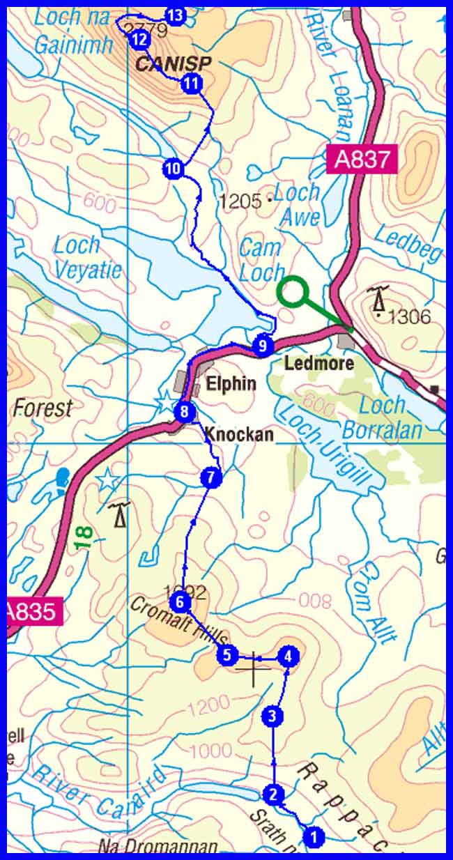
12 Canisp (C)
13 By Loch na Faoileige (wild camp around NC 210 192 - 450 metres)
Plan
27 km
1412 metres ascent
11.6 hours
(1 Corbett)
Actual
Day 19 - Interim Report (Sunday):
The Cromalt Hills were an absolute nightmare. Bent my knees and poles. So no Canisp. Will pitch camp near Lochan Fada [Point 10]. Tomorrow's route is via Alltan Beithe to Inchnadamph and Kylesku.
Full Report:
After breaking camp I headed via Clar Lochan to the Cromalt Hills. Clar Lochan has some nice camping spots. Climbing Meallan Odhar was fairly easy. Afterwards the Cromalt Hills showed their true character. A hillwalker's nightmare. Plastered with peat hags and boggy bits. At least they offered exceptional views. Came across a nice tea room at Elphin. Which lifted my spirits. Assynt is a magic place. Every peak has its own character. From Elphin I followed a track to Lochan Fada. Arrived there at 8 pm. Fearing I wouldn't find a suitable place for my wee tent. But there it was. The perfect place. With mighty Suilven in view. And a glorious sunset.
Day 20 - Monday 3 May
1 Wild camp by Loch na Faoileige
2 Alltan Beithe
3 Stronchrubie
4 Inchnadamph
5 Loch Fleodach Coire
6 Path junction to Glas Bheinn
7 Glas Bheinn (C)
8 A894 road by Loch na Gainmhich
9 Unapool
10 Kylesku (Hotel)
Plan
24 km
927 metres ascent
10.0 hours
(1 Corbett)
Actual
Day 20 Report (Monday):
A very cold morning again. It felt hard to leave the warmth of the tent. At least there was some sunshine and the promise for blue skies. On pathless terrain to Meallan Liath Mor. En route I disturbed the privacy of some grouse. Down under I wasn't able to spot a bridge over the River Loanan. With gaiters on I managed a dry crossing. The Inchnadamph Hotel doesn't seem to cater for non-residents. Decided against the high-level route over Glas Bheinn and followed an old track past Achmore Farm to Loch na Gainmhich. Impressive views towards Quinag. On the road down to Kylesku. One of the best view spots in Britain. Got a room at the Kylesku Hotel, a wonderful place. Enjoyed a superb meal and a good choice of wines. And a nice chat with a waitress from Bavaria.
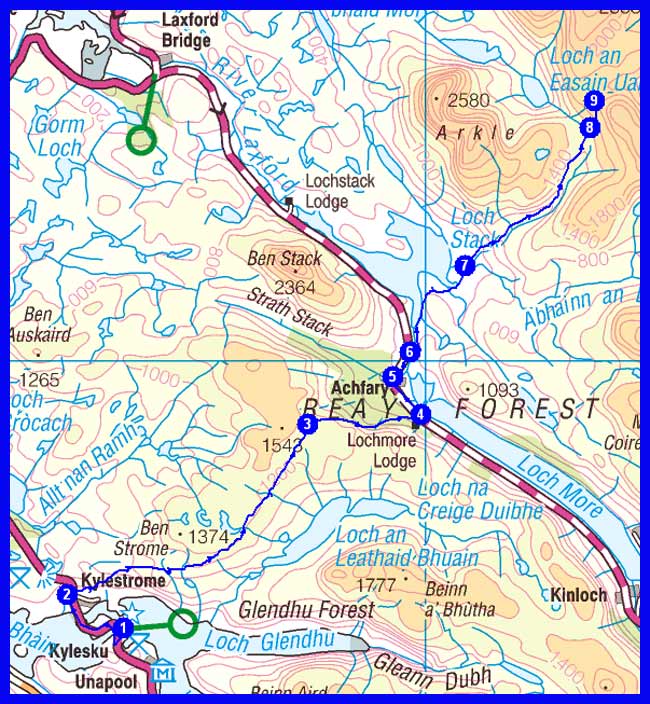
Day 21 - Tuesday 4 May
1 Kylesku
2 Kylestrome
3 Bealach nam Fiann
4 Lochmore Lodge
5 Achfary
6 Parking spot on A838 road
7 Lone
8 Path to Meall Horn
9 Bealach Horn (wild camp around NC 339 460 - 520 metres)
Plan
23 km
1179 metres ascent
9.7 hours
Actual
Day 21 - Interim Report (Tuesday):
A day of rain and grey. Followed the road to Scourie instead of going over the hills. Staying there on the campsite.
Full Report:
Today's foul weather didn't feel very motivating for a day out in the hills. So it was on the winding coastal road to Scourie. Arrived there at 1 pm. In driving rain. Rest of the day was viva siesta on the local campsite. Scourie hasn't much to offer.
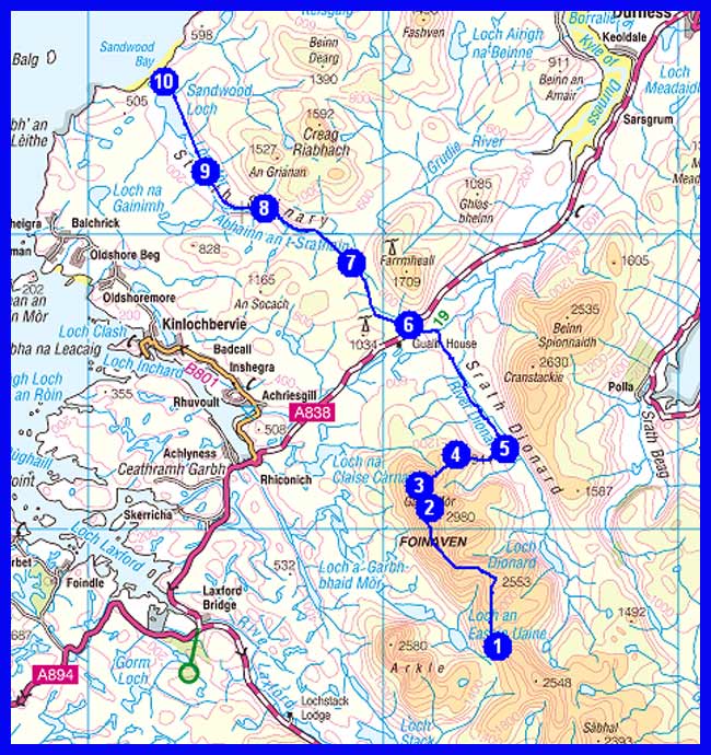
Day 22 - Wednesday 5 May
1 Wild camp at Bealach Horn
2 Foinaven (C)
3 Ceann Garbh
4 Cnoc a' Mhadaidh
5 Join Land Rover Track
6 By Gualin House
7 Feur Loch
8 By Abhainn an t-Srathain
9 Strath Shinary
10 Sandwood Bay (wild camp around NC 226 653 - 10 metres)
Plan
30 km
1200 metres ascent
12.8 hours
(1 Corbett)
Actual
Report to follow.
Day 23 - Thursday 6 May
1 Wild camp at Sandwood Bay
2 Cnoc a' Gheodha Ruaidh
3 Bay of Keisgaig
4 Sithean na h-Iolaireich
5 Dunan Beag
6 Cape Wrath (for minibus to Durness then 'all stations' to Dornbirn)
Plan
11 km
600 metres ascent
5.0 hours
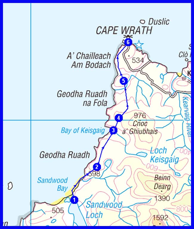
Actual
Day 23 - Interim Reports (Wednesday):
1. Thanks Martin for the informative and Jehovas Witness style forecast [MWIS appeared to predict an apocalypse! - M]. No good news. Didn't make it to the Cape. HM troops stopped me. The red flags were up. Tried yesterday to contact Durness Tourist Information and the ferry operator. Without success. Seemingly I was given the wrong numbers by Kylesku Hotel! Now it's back by bus.
2. Can live with it. The trail was my target. Had many magic moments. And great company. That counts.
3. Hi Martin! A shame. Sunny and mild weather is returning when I'm on my way back home. Met three CWT walkers from England on the bus who simply ignored the flags. That's why Mr Bond is a Brit and not an Austrian. Will send you my last two reports next week by email.
Plan
Total Distance 574 km (359 miles)
Total Ascent 21,100 metres, approx
Time 227 hours including stops
9 Munros
4 Corbetts
NB Timings are based on 3.5 kph, plus an hour for each 500 metres of ascent and another hour for each 1000 metres of descent.