Home
Saturday 3 July 2004
Bike ride from Bowness
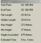
Ferry Car Park (SD 398 959)
Here are details of the
route and a map.
Call us on 07968 122170 if you are coming but running late.
Regards,
Martin and Sue
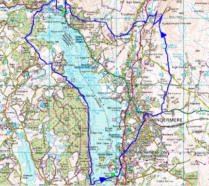
Cycle ride around Windermere
from Bowness
Route Summary
1 -> 2 -> 1
Instructions
1 (SD 398 959) Car Park at Bowness, on the right before the
ferry, 9.30am.
1 -> 2 (16.74 Km) Take the main road through Bowness and
Windermere, turning right onto the A591. Go up and over the hill, and turn
first left down quiet lane to Heaning and Mislet. Go straight on at cross
roads with seat, to T-junction. Turn left, then 2nd right after 200m - Dubbs
Road. Climb this bridleway, past the reservoir. Turn left at hairpin overlooking
Troutbeck and caravansite. Hairpin right at gate, then left into caravansite.
Turn left onto main road, right at church, up into the village. Turn left
at the top to the post office, then take bridleway up to the right, climbing
before bearing left at a contouring path at the top, going through gate with
signs on the left. Continue down past fallen down barn, through gates to road.
Turn right uphill into the farmyard, through the far gate, another gate immediately,
then follow this track watching out for Jenkins Crag on the left. Take the
main path, taking care to avoid rocks and pedestrians on the long hill down
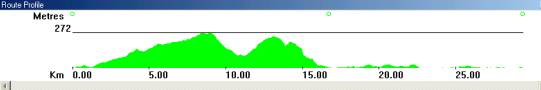
into Ambleside. Turn left to Ambleside (17km, 488mtrs ascent) and enjoy an
ice cream, snack or drink by the lake.
This should take 2.5 hours given a flat speed of 10kph + 600metres per hour
additional ascent time.
2 (NY 376 032) Waterhead.
2 -> 1 (12.61 Km) Follow the Hawkshead / Coniston signs
out of Ambleside, over the Rothay Bridge into Clappersgate. Turn left towards
Hawkshead and follow the road for 2 miles, turning left again towards High
Wray and Low Wray. Wind down past the campsite on the left, and up to the
Dower House. Here take the bridleway to the left, down to the lake, and follow
this for 4 pleasant miles down the shore, then back onto tarmac and left at
the T-junction, to the Ferry back to Bowness.
The 13km, including 187metres of ascent, should take about 1.5 hours.
1 (SD 398 959) Car Park at Bowness, on the left after the
ferry.